You are here: Home > Network List > CI - Caltech Regional Seismic Network Stations List
> Station BFS Mt Baldy Forest Station > Earthquake Result Viewer
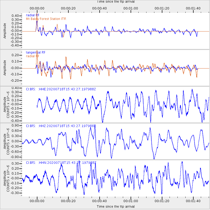
BFS Mt Baldy Forest Station - Earthquake Result Viewer
*The percent match for this event was below the threshold and hence no stack was calculated.
| Earthquake location: |
Samoa Islands Region |
| Earthquake latitude/longitude: |
-15.3/-172.6 |
| Earthquake time(UTC): |
2020/07/18 (200) 15:32:35 GMT |
| Earthquake Depth: |
10 km |
| Earthquake Magnitude: |
6.2 Mww |
| Earthquake Catalog/Contributor: |
NEIC PDE/us |
|
| Network: |
CI Caltech Regional Seismic Network |
| Station: |
BFS Mt Baldy Forest Station |
| Lat/Lon: |
34.24 N/117.66 W |
| Elevation: |
1312 m |
|
| Distance: |
71.8 deg |
| Az: |
45.579 deg |
| Baz: |
236.308 deg |
| Ray Param: |
$rayparam |
*The percent match for this event was below the threshold and hence was not used in the summary stack. |
|
| Radial Match: |
74.16601 % |
| Radial Bump: |
400 |
| Transverse Match: |
63.321148 % |
| Transverse Bump: |
400 |
| SOD ConfigId: |
21709731 |
| Insert Time: |
2020-08-01 15:38:25.078 +0000 |
| GWidth: |
2.5 |
| Max Bumps: |
400 |
| Tol: |
0.001 |
|
Signal To Noise
| Channel | StoN | STA | LTA |
| CI:BFS: :HHZ:20200718T15:43:27.197988Z | 0.65419394 | 1.10892785E-7 | 1.6951057E-7 |
| CI:BFS: :HHN:20200718T15:43:27.197988Z | 1.2725744 | 6.049277E-8 | 4.753575E-8 |
| CI:BFS: :HHE:20200718T15:43:27.197988Z | 1.0434347 | 1.1112305E-7 | 1.0649737E-7 |
| Arrivals |
| Ps | |
| PpPs | |
| PsPs/PpSs | |


