You are here: Home > Network List > IU - Global Seismograph Network (GSN - IRIS/USGS) Stations List
> Station JOHN Johnston Island, USA > Earthquake Result Viewer
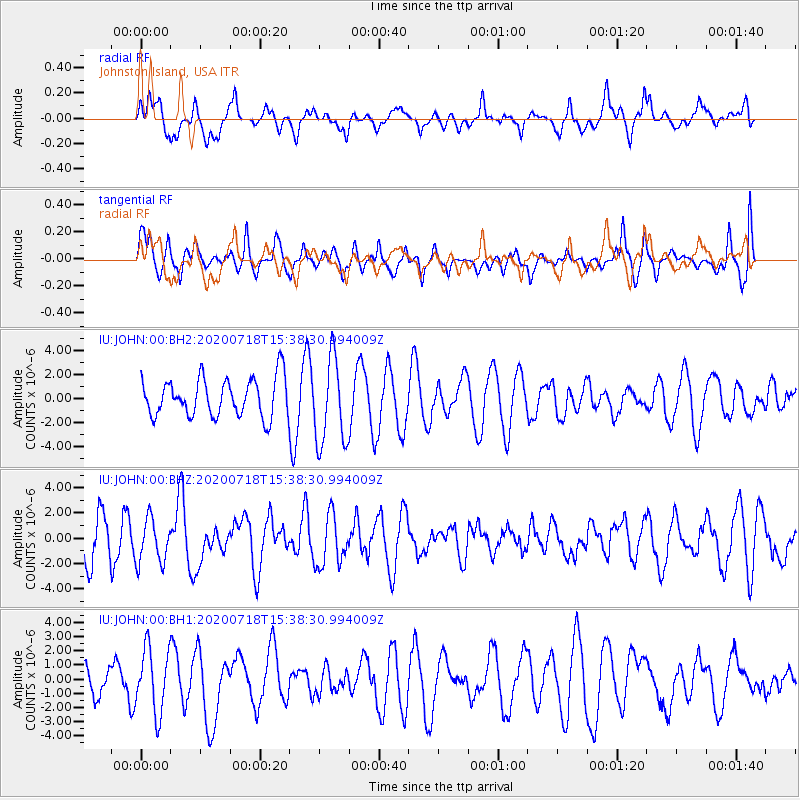
JOHN Johnston Island, USA - Earthquake Result Viewer
*The percent match for this event was below the threshold and hence no stack was calculated.
| Earthquake location: |
Samoa Islands Region |
| Earthquake latitude/longitude: |
-15.3/-172.6 |
| Earthquake time(UTC): |
2020/07/18 (200) 15:32:35 GMT |
| Earthquake Depth: |
10 km |
| Earthquake Magnitude: |
6.2 Mww |
| Earthquake Catalog/Contributor: |
NEIC PDE/us |
|
| Network: |
IU Global Seismograph Network (GSN - IRIS/USGS) |
| Station: |
JOHN Johnston Island, USA |
| Lat/Lon: |
16.73 N/169.53 W |
| Elevation: |
2.0 m |
|
| Distance: |
32.0 deg |
| Az: |
5.654 deg |
| Baz: |
185.695 deg |
| Ray Param: |
$rayparam |
*The percent match for this event was below the threshold and hence was not used in the summary stack. |
|
| Radial Match: |
50.835938 % |
| Radial Bump: |
400 |
| Transverse Match: |
57.86084 % |
| Transverse Bump: |
400 |
| SOD ConfigId: |
21709731 |
| Insert Time: |
2020-08-01 15:41:38.698 +0000 |
| GWidth: |
2.5 |
| Max Bumps: |
400 |
| Tol: |
0.001 |
|
Signal To Noise
| Channel | StoN | STA | LTA |
| IU:JOHN:00:BHZ:20200718T15:38:30.994009Z | 0.9260802 | 1.7426893E-6 | 1.8817907E-6 |
| IU:JOHN:00:BH1:20200718T15:38:30.994009Z | 2.120187 | 2.2578301E-6 | 1.0649203E-6 |
| IU:JOHN:00:BH2:20200718T15:38:30.994009Z | 2.270613 | 3.5934115E-6 | 1.5825733E-6 |
| Arrivals |
| Ps | |
| PpPs | |
| PsPs/PpSs | |


