You are here: Home > Network List > TD - TransAlta Monitoring Network Stations List
> Station TD029 Z > Earthquake Result Viewer
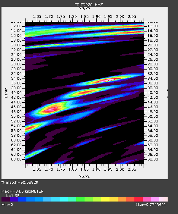
TD029 Z - Earthquake Result Viewer
| Earthquake location: |
Samoa Islands Region |
| Earthquake latitude/longitude: |
-15.3/-172.6 |
| Earthquake time(UTC): |
2020/07/18 (200) 15:32:35 GMT |
| Earthquake Depth: |
10 km |
| Earthquake Magnitude: |
6.2 Mww |
| Earthquake Catalog/Contributor: |
NEIC PDE/us |
|
| Network: |
TD TransAlta Monitoring Network |
| Station: |
TD029 Z |
| Lat/Lon: |
52.22 N/115.20 W |
| Elevation: |
1164 m |
|
| Distance: |
83.5 deg |
| Az: |
31.462 deg |
| Baz: |
234.96 deg |
| Ray Param: |
0.04614312 |
| Estimated Moho Depth: |
34.5 km |
| Estimated Crust Vp/Vs: |
1.95 |
| Assumed Crust Vp: |
6.426 km/s |
| Estimated Crust Vs: |
3.295 km/s |
| Estimated Crust Poisson's Ratio: |
0.32 |
|
| Radial Match: |
90.08929 % |
| Radial Bump: |
400 |
| Transverse Match: |
81.55931 % |
| Transverse Bump: |
400 |
| SOD ConfigId: |
21709731 |
| Insert Time: |
2020-08-01 15:47:58.268 +0000 |
| GWidth: |
2.5 |
| Max Bumps: |
400 |
| Tol: |
0.001 |
|

Signal To Noise
| Channel | StoN | STA | LTA |
| TD:TD029: :HHZ:20200718T15:44:32.200002Z | 0.42795795 | 4.5047155E-8 | 1.052607E-7 |
| TD:TD029: :HH1:20200718T15:44:32.200002Z | 2.2122872 | 1.5936274E-7 | 7.203529E-8 |
| TD:TD029: :HH2:20200718T15:44:32.200002Z | 0.4423793 | 4.302938E-8 | 9.726808E-8 |
| Arrivals |
| Ps | 5.2 SECOND |
| PpPs | 15 SECOND |
| PsPs/PpSs | 21 SECOND |


