You are here: Home > Network List > IU - Global Seismograph Network (GSN - IRIS/USGS) Stations List
> Station PMG Port Moresby, New Guinea > Earthquake Result Viewer
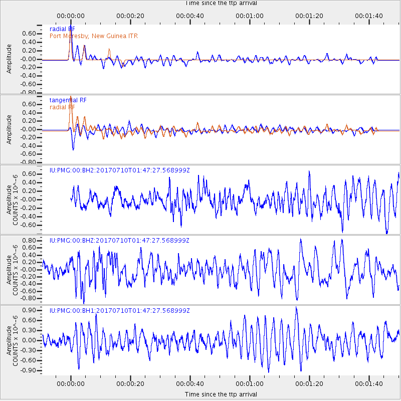
PMG Port Moresby, New Guinea - Earthquake Result Viewer
*The percent match for this event was below the threshold and hence no stack was calculated.
| Earthquake location: |
Leyte, Philippines |
| Earthquake latitude/longitude: |
11.0/124.8 |
| Earthquake time(UTC): |
2017/07/10 (191) 01:41:48 GMT |
| Earthquake Depth: |
7.1 km |
| Earthquake Magnitude: |
5.8 Mww |
| Earthquake Catalog/Contributor: |
NEIC PDE/us |
|
| Network: |
IU Global Seismograph Network (GSN - IRIS/USGS) |
| Station: |
PMG Port Moresby, New Guinea |
| Lat/Lon: |
9.40 S/147.16 E |
| Elevation: |
90 m |
|
| Distance: |
30.1 deg |
| Az: |
131.49 deg |
| Baz: |
311.807 deg |
| Ray Param: |
$rayparam |
*The percent match for this event was below the threshold and hence was not used in the summary stack. |
|
| Radial Match: |
78.6697 % |
| Radial Bump: |
400 |
| Transverse Match: |
66.32943 % |
| Transverse Bump: |
400 |
| SOD ConfigId: |
2140511 |
| Insert Time: |
2017-07-23 17:34:51.234 +0000 |
| GWidth: |
2.5 |
| Max Bumps: |
400 |
| Tol: |
0.001 |
|
Signal To Noise
| Channel | StoN | STA | LTA |
| IU:PMG:00:BHZ:20170710T01:47:27.568999Z | 3.7433946 | 4.2790205E-7 | 1.14308556E-7 |
| IU:PMG:00:BH1:20170710T01:47:27.568999Z | 2.5853522 | 3.5315287E-7 | 1.3659758E-7 |
| IU:PMG:00:BH2:20170710T01:47:27.568999Z | 1.420336 | 2.1132333E-7 | 1.4878404E-7 |
| Arrivals |
| Ps | |
| PpPs | |
| PsPs/PpSs | |


