You are here: Home > Network List > AV - Alaska Volcano Observatory Stations List
> Station MAPS Pakushin Southeast, Makushin Volcano, Alaska > Earthquake Result Viewer
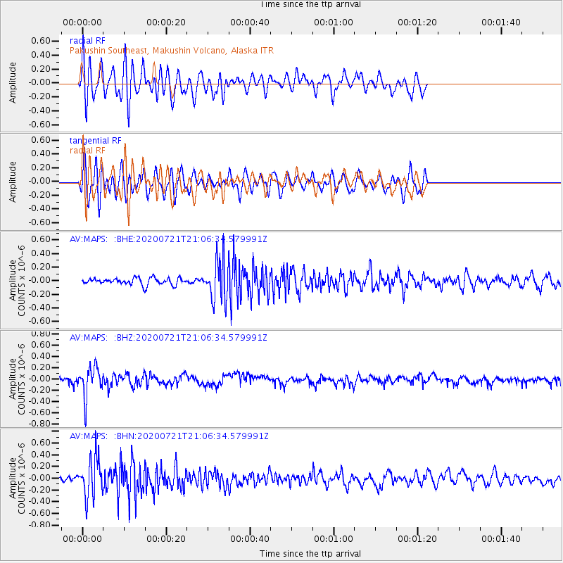
MAPS Pakushin Southeast, Makushin Volcano, Alaska - Earthquake Result Viewer
*The percent match for this event was below the threshold and hence no stack was calculated.
| Earthquake location: |
Fiji Islands Region |
| Earthquake latitude/longitude: |
-20.8/-178.6 |
| Earthquake time(UTC): |
2020/07/21 (203) 20:56:24 GMT |
| Earthquake Depth: |
602 km |
| Earthquake Magnitude: |
6.0 mww |
| Earthquake Catalog/Contributor: |
NEIC PDE/us |
|
| Network: |
AV Alaska Volcano Observatory |
| Station: |
MAPS Pakushin Southeast, Makushin Volcano, Alaska |
| Lat/Lon: |
53.81 N/166.94 W |
| Elevation: |
333 m |
|
| Distance: |
75.0 deg |
| Az: |
7.111 deg |
| Baz: |
191.259 deg |
| Ray Param: |
$rayparam |
*The percent match for this event was below the threshold and hence was not used in the summary stack. |
|
| Radial Match: |
59.281338 % |
| Radial Bump: |
400 |
| Transverse Match: |
62.2818 % |
| Transverse Bump: |
400 |
| SOD ConfigId: |
21709731 |
| Insert Time: |
2020-08-04 21:02:33.258 +0000 |
| GWidth: |
2.5 |
| Max Bumps: |
400 |
| Tol: |
0.001 |
|
Signal To Noise
| Channel | StoN | STA | LTA |
| AV:MAPS: :BHZ:20200721T21:06:34.579991Z | 4.2565312 | 2.6169755E-7 | 6.148141E-8 |
| AV:MAPS: :BHN:20200721T21:06:34.579991Z | 8.019795 | 3.3060832E-7 | 4.1224034E-8 |
| AV:MAPS: :BHE:20200721T21:06:34.579991Z | 6.0495615 | 2.949934E-7 | 4.8762775E-8 |
| Arrivals |
| Ps | |
| PpPs | |
| PsPs/PpSs | |


