You are here: Home > Network List > CI - Caltech Regional Seismic Network Stations List
> Station MPM Manuel Prospect Mine, California, USA > Earthquake Result Viewer
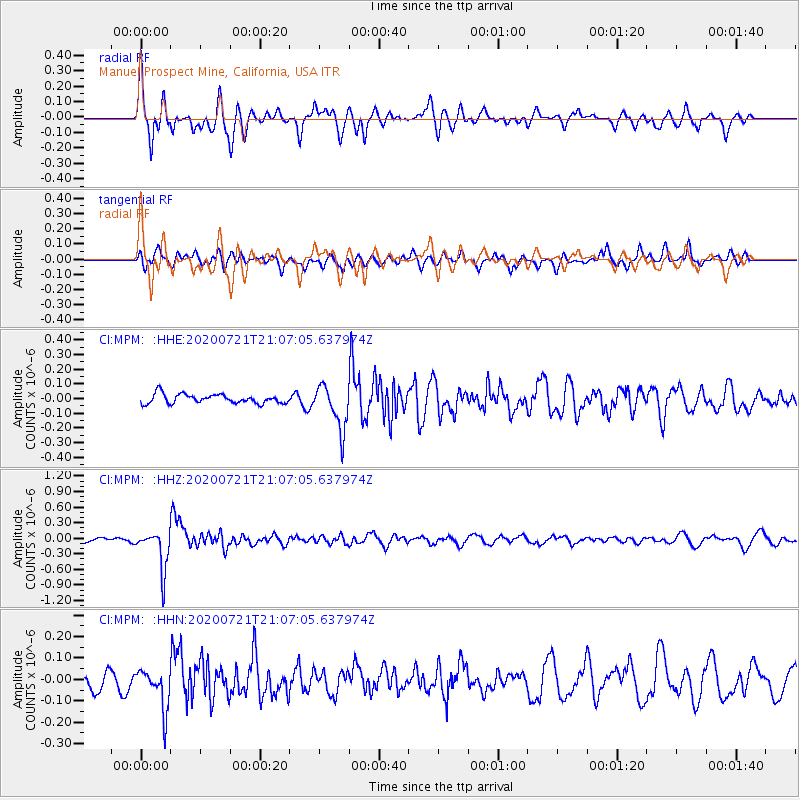
MPM Manuel Prospect Mine, California, USA - Earthquake Result Viewer
*The percent match for this event was below the threshold and hence no stack was calculated.
| Earthquake location: |
Fiji Islands Region |
| Earthquake latitude/longitude: |
-20.8/-178.6 |
| Earthquake time(UTC): |
2020/07/21 (203) 20:56:24 GMT |
| Earthquake Depth: |
602 km |
| Earthquake Magnitude: |
6.0 mww |
| Earthquake Catalog/Contributor: |
NEIC PDE/us |
|
| Network: |
CI Caltech Regional Seismic Network |
| Station: |
MPM Manuel Prospect Mine, California, USA |
| Lat/Lon: |
36.06 N/117.49 W |
| Elevation: |
185 m |
|
| Distance: |
80.8 deg |
| Az: |
45.927 deg |
| Baz: |
236.036 deg |
| Ray Param: |
$rayparam |
*The percent match for this event was below the threshold and hence was not used in the summary stack. |
|
| Radial Match: |
75.78488 % |
| Radial Bump: |
400 |
| Transverse Match: |
60.476852 % |
| Transverse Bump: |
400 |
| SOD ConfigId: |
21709731 |
| Insert Time: |
2020-08-04 21:06:34.217 +0000 |
| GWidth: |
2.5 |
| Max Bumps: |
400 |
| Tol: |
0.001 |
|
Signal To Noise
| Channel | StoN | STA | LTA |
| CI:MPM: :HHZ:20200721T21:07:05.637974Z | 7.144046 | 3.8390277E-7 | 5.3737445E-8 |
| CI:MPM: :HHN:20200721T21:07:05.637974Z | 2.937962 | 9.722355E-8 | 3.3092174E-8 |
| CI:MPM: :HHE:20200721T21:07:05.637974Z | 4.806378 | 1.526208E-7 | 3.1753807E-8 |
| Arrivals |
| Ps | |
| PpPs | |
| PsPs/PpSs | |


