You are here: Home > Network List > CI - Caltech Regional Seismic Network Stations List
> Station MUR Murrieta > Earthquake Result Viewer
MUR Murrieta - Earthquake Result Viewer
*The percent match for this event was below the threshold and hence no stack was calculated.
| Earthquake location: |
Fiji Islands Region |
| Earthquake latitude/longitude: |
-20.8/-178.6 |
| Earthquake time(UTC): |
2020/07/21 (203) 20:56:24 GMT |
| Earthquake Depth: |
602 km |
| Earthquake Magnitude: |
6.0 mww |
| Earthquake Catalog/Contributor: |
NEIC PDE/us |
|
| Network: |
CI Caltech Regional Seismic Network |
| Station: |
MUR Murrieta |
| Lat/Lon: |
33.60 N/117.20 W |
| Elevation: |
562 m |
|
| Distance: |
79.7 deg |
| Az: |
48.133 deg |
| Baz: |
236.576 deg |
| Ray Param: |
$rayparam |
*The percent match for this event was below the threshold and hence was not used in the summary stack. |
|
| Radial Match: |
64.45733 % |
| Radial Bump: |
400 |
| Transverse Match: |
46.679207 % |
| Transverse Bump: |
400 |
| SOD ConfigId: |
21709731 |
| Insert Time: |
2020-08-04 21:06:37.940 +0000 |
| GWidth: |
2.5 |
| Max Bumps: |
400 |
| Tol: |
0.001 |
|
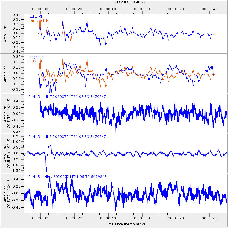
Signal To Noise
| Channel | StoN | STA | LTA |
| CI:MUR: :HHZ:20200721T21:06:59.647984Z | 4.8086567 | 4.9453956E-7 | 1.0284359E-7 |
| CI:MUR: :HHN:20200721T21:06:59.647984Z | 1.4398007 | 1.6546639E-7 | 1.1492312E-7 |
| CI:MUR: :HHE:20200721T21:06:59.647984Z | 1.4530766 | 1.8232676E-7 | 1.2547636E-7 |
| Arrivals |
| Ps | |
| PpPs | |
| PsPs/PpSs | |


