You are here: Home > Network List > IU - Global Seismograph Network (GSN - IRIS/USGS) Stations List
> Station PMG Port Moresby, New Guinea > Earthquake Result Viewer
PMG Port Moresby, New Guinea - Earthquake Result Viewer
*The percent match for this event was below the threshold and hence no stack was calculated.
| Earthquake location: |
Fiji Islands Region |
| Earthquake latitude/longitude: |
-20.8/-178.6 |
| Earthquake time(UTC): |
2020/07/21 (203) 20:56:24 GMT |
| Earthquake Depth: |
602 km |
| Earthquake Magnitude: |
6.0 mww |
| Earthquake Catalog/Contributor: |
NEIC PDE/us |
|
| Network: |
IU Global Seismograph Network (GSN - IRIS/USGS) |
| Station: |
PMG Port Moresby, New Guinea |
| Lat/Lon: |
9.40 S/147.16 E |
| Elevation: |
90 m |
|
| Distance: |
34.9 deg |
| Az: |
283.797 deg |
| Baz: |
112.98 deg |
| Ray Param: |
$rayparam |
*The percent match for this event was below the threshold and hence was not used in the summary stack. |
|
| Radial Match: |
82.647934 % |
| Radial Bump: |
400 |
| Transverse Match: |
79.33417 % |
| Transverse Bump: |
400 |
| SOD ConfigId: |
21709731 |
| Insert Time: |
2020-08-04 21:10:20.081 +0000 |
| GWidth: |
2.5 |
| Max Bumps: |
400 |
| Tol: |
0.001 |
|
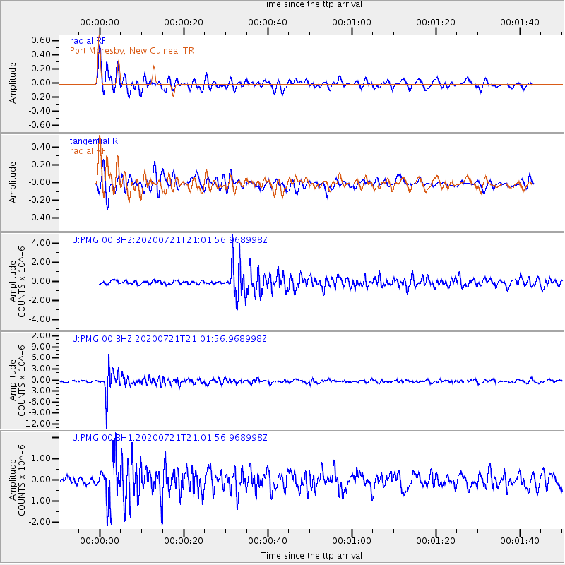
Signal To Noise
| Channel | StoN | STA | LTA |
| IU:PMG:00:BHZ:20200721T21:01:56.968998Z | 20.687798 | 3.542658E-6 | 1.7124385E-7 |
| IU:PMG:00:BH1:20200721T21:01:56.968998Z | 6.8142247 | 9.423706E-7 | 1.3829462E-7 |
| IU:PMG:00:BH2:20200721T21:01:56.968998Z | 11.035067 | 1.7806333E-6 | 1.6136136E-7 |
| Arrivals |
| Ps | |
| PpPs | |
| PsPs/PpSs | |


