You are here: Home > Network List > TA - USArray Transportable Network (new EarthScope stations) Stations List
> Station D23K Nanushuk River, AK USA > Earthquake Result Viewer
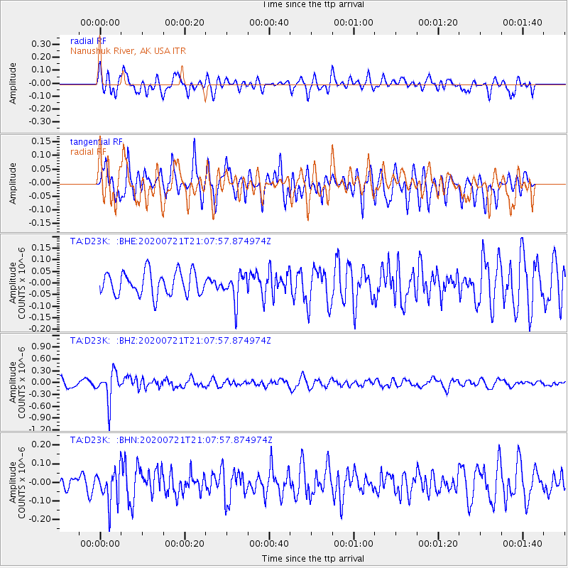
D23K Nanushuk River, AK USA - Earthquake Result Viewer
*The percent match for this event was below the threshold and hence no stack was calculated.
| Earthquake location: |
Fiji Islands Region |
| Earthquake latitude/longitude: |
-20.8/-178.6 |
| Earthquake time(UTC): |
2020/07/21 (203) 20:56:24 GMT |
| Earthquake Depth: |
602 km |
| Earthquake Magnitude: |
6.0 mww |
| Earthquake Catalog/Contributor: |
NEIC PDE/us |
|
| Network: |
TA USArray Transportable Network (new EarthScope stations) |
| Station: |
D23K Nanushuk River, AK USA |
| Lat/Lon: |
68.97 N/150.68 W |
| Elevation: |
406 m |
|
| Distance: |
91.8 deg |
| Az: |
9.728 deg |
| Baz: |
205.964 deg |
| Ray Param: |
$rayparam |
*The percent match for this event was below the threshold and hence was not used in the summary stack. |
|
| Radial Match: |
62.79895 % |
| Radial Bump: |
400 |
| Transverse Match: |
61.35633 % |
| Transverse Bump: |
400 |
| SOD ConfigId: |
21709731 |
| Insert Time: |
2020-08-04 21:15:41.195 +0000 |
| GWidth: |
2.5 |
| Max Bumps: |
400 |
| Tol: |
0.001 |
|
Signal To Noise
| Channel | StoN | STA | LTA |
| TA:D23K: :BHZ:20200721T21:07:57.874974Z | 3.5698936 | 3.8229268E-7 | 1.07087985E-7 |
| TA:D23K: :BHN:20200721T21:07:57.874974Z | 2.0390205 | 9.197754E-8 | 4.510869E-8 |
| TA:D23K: :BHE:20200721T21:07:57.874974Z | 1.2404164 | 6.218079E-8 | 5.0128968E-8 |
| Arrivals |
| Ps | |
| PpPs | |
| PsPs/PpSs | |


