You are here: Home > Network List > TA - USArray Transportable Network (new EarthScope stations) Stations List
> Station G21K Allakaket, AK, USA > Earthquake Result Viewer
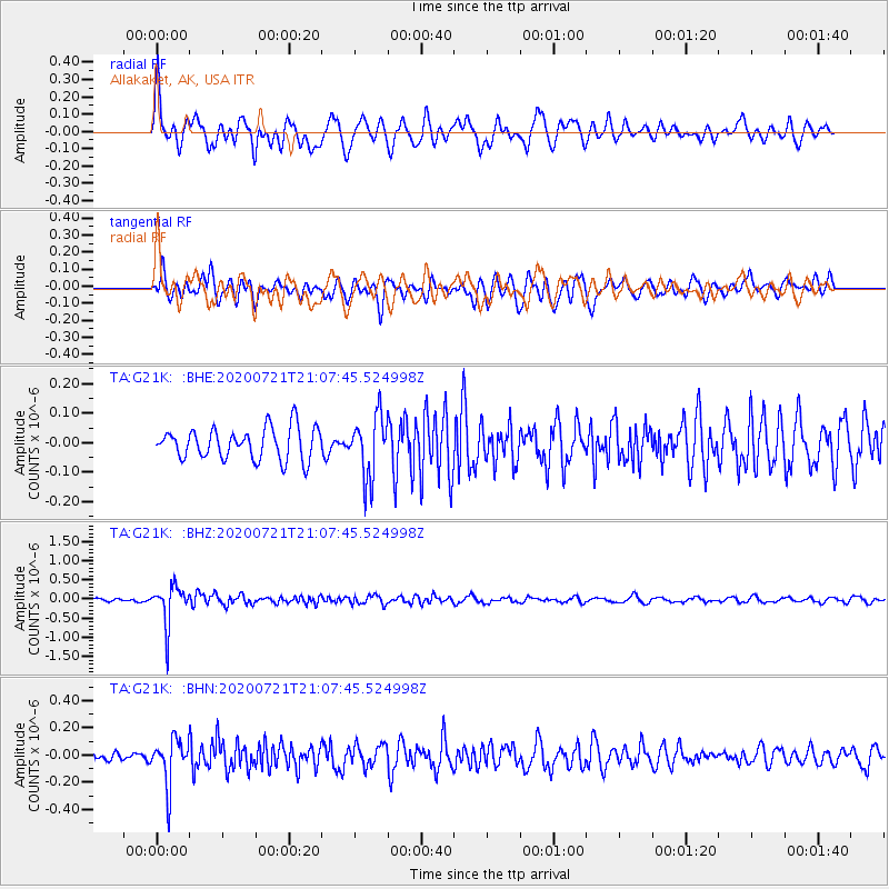
G21K Allakaket, AK, USA - Earthquake Result Viewer
*The percent match for this event was below the threshold and hence no stack was calculated.
| Earthquake location: |
Fiji Islands Region |
| Earthquake latitude/longitude: |
-20.8/-178.6 |
| Earthquake time(UTC): |
2020/07/21 (203) 20:56:24 GMT |
| Earthquake Depth: |
602 km |
| Earthquake Magnitude: |
6.0 mww |
| Earthquake Catalog/Contributor: |
NEIC PDE/us |
|
| Network: |
TA USArray Transportable Network (new EarthScope stations) |
| Station: |
G21K Allakaket, AK, USA |
| Lat/Lon: |
66.52 N/153.51 W |
| Elevation: |
446 m |
|
| Distance: |
89.1 deg |
| Az: |
9.777 deg |
| Baz: |
203.351 deg |
| Ray Param: |
$rayparam |
*The percent match for this event was below the threshold and hence was not used in the summary stack. |
|
| Radial Match: |
78.972595 % |
| Radial Bump: |
400 |
| Transverse Match: |
72.14494 % |
| Transverse Bump: |
400 |
| SOD ConfigId: |
21709731 |
| Insert Time: |
2020-08-04 21:16:30.396 +0000 |
| GWidth: |
2.5 |
| Max Bumps: |
400 |
| Tol: |
0.001 |
|
Signal To Noise
| Channel | StoN | STA | LTA |
| TA:G21K: :BHZ:20200721T21:07:45.524998Z | 10.63083 | 5.214905E-7 | 4.9054538E-8 |
| TA:G21K: :BHN:20200721T21:07:45.524998Z | 6.0180473 | 1.6776244E-7 | 2.7876556E-8 |
| TA:G21K: :BHE:20200721T21:07:45.524998Z | 1.9504834 | 1.03829E-7 | 5.3232444E-8 |
| Arrivals |
| Ps | |
| PpPs | |
| PsPs/PpSs | |


