You are here: Home > Network List > TA - USArray Transportable Network (new EarthScope stations) Stations List
> Station G31M Satah River, YT, CAN > Earthquake Result Viewer
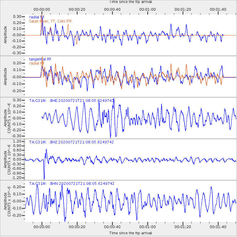
G31M Satah River, YT, CAN - Earthquake Result Viewer
*The percent match for this event was below the threshold and hence no stack was calculated.
| Earthquake location: |
Fiji Islands Region |
| Earthquake latitude/longitude: |
-20.8/-178.6 |
| Earthquake time(UTC): |
2020/07/21 (203) 20:56:24 GMT |
| Earthquake Depth: |
602 km |
| Earthquake Magnitude: |
6.0 mww |
| Earthquake Catalog/Contributor: |
NEIC PDE/us |
|
| Network: |
TA USArray Transportable Network (new EarthScope stations) |
| Station: |
G31M Satah River, YT, CAN |
| Lat/Lon: |
66.92 N/134.27 W |
| Elevation: |
61 m |
|
| Distance: |
93.5 deg |
| Az: |
16.012 deg |
| Baz: |
220.885 deg |
| Ray Param: |
$rayparam |
*The percent match for this event was below the threshold and hence was not used in the summary stack. |
|
| Radial Match: |
53.312057 % |
| Radial Bump: |
345 |
| Transverse Match: |
43.162804 % |
| Transverse Bump: |
385 |
| SOD ConfigId: |
21709731 |
| Insert Time: |
2020-08-04 21:16:41.336 +0000 |
| GWidth: |
2.5 |
| Max Bumps: |
400 |
| Tol: |
0.001 |
|
Signal To Noise
| Channel | StoN | STA | LTA |
| TA:G31M: :BHZ:20200721T21:08:05.624974Z | 5.323419 | 3.8606834E-7 | 7.2522624E-8 |
| TA:G31M: :BHN:20200721T21:08:05.624974Z | 1.0926347 | 1.0271026E-7 | 9.400238E-8 |
| TA:G31M: :BHE:20200721T21:08:05.624974Z | 1.1747526 | 1.2678296E-7 | 1.0792312E-7 |
| Arrivals |
| Ps | |
| PpPs | |
| PsPs/PpSs | |


