You are here: Home > Network List > TA - USArray Transportable Network (new EarthScope stations) Stations List
> Station M11K Mekoryuk, AK, USA > Earthquake Result Viewer
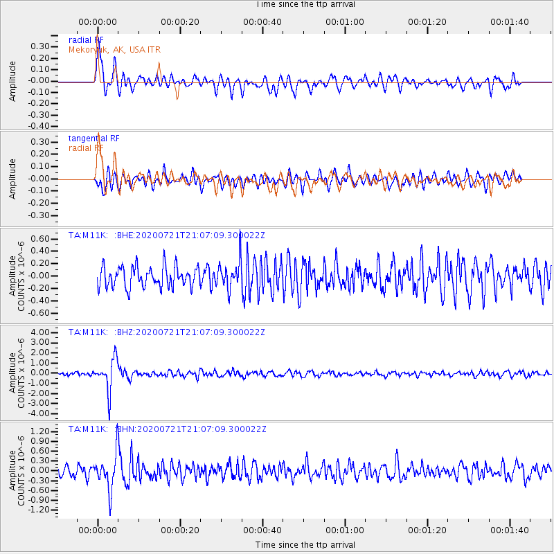
M11K Mekoryuk, AK, USA - Earthquake Result Viewer
*The percent match for this event was below the threshold and hence no stack was calculated.
| Earthquake location: |
Fiji Islands Region |
| Earthquake latitude/longitude: |
-20.8/-178.6 |
| Earthquake time(UTC): |
2020/07/21 (203) 20:56:24 GMT |
| Earthquake Depth: |
602 km |
| Earthquake Magnitude: |
6.0 mww |
| Earthquake Catalog/Contributor: |
NEIC PDE/us |
|
| Network: |
TA USArray Transportable Network (new EarthScope stations) |
| Station: |
M11K Mekoryuk, AK, USA |
| Lat/Lon: |
60.38 N/166.20 W |
| Elevation: |
3.0 m |
|
| Distance: |
81.5 deg |
| Az: |
6.176 deg |
| Baz: |
191.69 deg |
| Ray Param: |
$rayparam |
*The percent match for this event was below the threshold and hence was not used in the summary stack. |
|
| Radial Match: |
76.07522 % |
| Radial Bump: |
400 |
| Transverse Match: |
71.57145 % |
| Transverse Bump: |
400 |
| SOD ConfigId: |
21709731 |
| Insert Time: |
2020-08-04 21:17:18.796 +0000 |
| GWidth: |
2.5 |
| Max Bumps: |
400 |
| Tol: |
0.001 |
|
Signal To Noise
| Channel | StoN | STA | LTA |
| TA:M11K: :BHZ:20200721T21:07:09.300022Z | 10.112881 | 1.6148072E-6 | 1.5967825E-7 |
| TA:M11K: :BHN:20200721T21:07:09.300022Z | 4.0568247 | 5.582616E-7 | 1.3761048E-7 |
| TA:M11K: :BHE:20200721T21:07:09.300022Z | 1.3886329 | 2.27865E-7 | 1.6409304E-7 |
| Arrivals |
| Ps | |
| PpPs | |
| PsPs/PpSs | |


