You are here: Home > Network List > TA - USArray Transportable Network (new EarthScope stations) Stations List
> Station N14K Kuskokwak Creek, AK, USA > Earthquake Result Viewer
N14K Kuskokwak Creek, AK, USA - Earthquake Result Viewer
| Earthquake location: |
Fiji Islands Region |
| Earthquake latitude/longitude: |
-20.8/-178.6 |
| Earthquake time(UTC): |
2020/07/21 (203) 20:56:24 GMT |
| Earthquake Depth: |
602 km |
| Earthquake Magnitude: |
6.0 mww |
| Earthquake Catalog/Contributor: |
NEIC PDE/us |
|
| Network: |
TA USArray Transportable Network (new EarthScope stations) |
| Station: |
N14K Kuskokwak Creek, AK, USA |
| Lat/Lon: |
59.92 N/161.69 W |
| Elevation: |
21 m |
|
| Distance: |
81.6 deg |
| Az: |
8.504 deg |
| Baz: |
195.941 deg |
| Ray Param: |
0.045615107 |
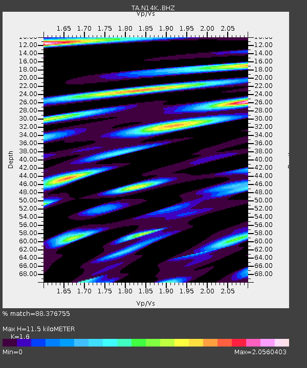
| Estimated Moho Depth: |
11.5 km |
| Estimated Crust Vp/Vs: |
1.60 |
| Assumed Crust Vp: |
6.24 km/s |
| Estimated Crust Vs: |
3.9 km/s |
| Estimated Crust Poisson's Ratio: |
0.18 |
|
| Radial Match: |
88.376755 % |
| Radial Bump: |
400 |
| Transverse Match: |
80.82893 % |
| Transverse Bump: |
400 |
| SOD ConfigId: |
21709731 |
| Insert Time: |
2020-08-04 21:17:35.463 +0000 |
| GWidth: |
2.5 |
| Max Bumps: |
400 |
| Tol: |
0.001 |
|

Signal To Noise
| Channel | StoN | STA | LTA |
| TA:N14K: :BHZ:20200721T21:07:09.749974Z | 22.993858 | 2.3115026E-6 | 1.0052696E-7 |
| TA:N14K: :BHN:20200721T21:07:09.749974Z | 5.765602 | 1.2368172E-6 | 2.1451656E-7 |
| TA:N14K: :BHE:20200721T21:07:09.749974Z | 1.9234946 | 3.878036E-7 | 2.0161409E-7 |
| Arrivals |
| Ps | 1.1 SECOND |
| PpPs | 4.7 SECOND |
| PsPs/PpSs | 5.8 SECOND |


