You are here: Home > Network List > TA - USArray Transportable Network (new EarthScope stations) Stations List
> Station O17K Koliganek, Bristol Bay, AK, USA > Earthquake Result Viewer
O17K Koliganek, Bristol Bay, AK, USA - Earthquake Result Viewer
| Earthquake location: |
Fiji Islands Region |
| Earthquake latitude/longitude: |
-20.8/-178.6 |
| Earthquake time(UTC): |
2020/07/21 (203) 20:56:24 GMT |
| Earthquake Depth: |
602 km |
| Earthquake Magnitude: |
6.0 mww |
| Earthquake Catalog/Contributor: |
NEIC PDE/us |
|
| Network: |
TA USArray Transportable Network (new EarthScope stations) |
| Station: |
O17K Koliganek, Bristol Bay, AK, USA |
| Lat/Lon: |
59.77 N/157.09 W |
| Elevation: |
156 m |
|
| Distance: |
82.2 deg |
| Az: |
10.776 deg |
| Baz: |
200.223 deg |
| Ray Param: |
0.045227703 |
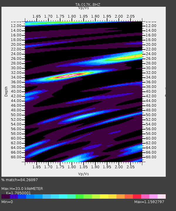
| Estimated Moho Depth: |
33.0 km |
| Estimated Crust Vp/Vs: |
1.79 |
| Assumed Crust Vp: |
6.276 km/s |
| Estimated Crust Vs: |
3.516 km/s |
| Estimated Crust Poisson's Ratio: |
0.27 |
|
| Radial Match: |
84.26897 % |
| Radial Bump: |
339 |
| Transverse Match: |
76.57099 % |
| Transverse Bump: |
364 |
| SOD ConfigId: |
21709731 |
| Insert Time: |
2020-08-04 21:17:48.953 +0000 |
| GWidth: |
2.5 |
| Max Bumps: |
400 |
| Tol: |
0.001 |
|
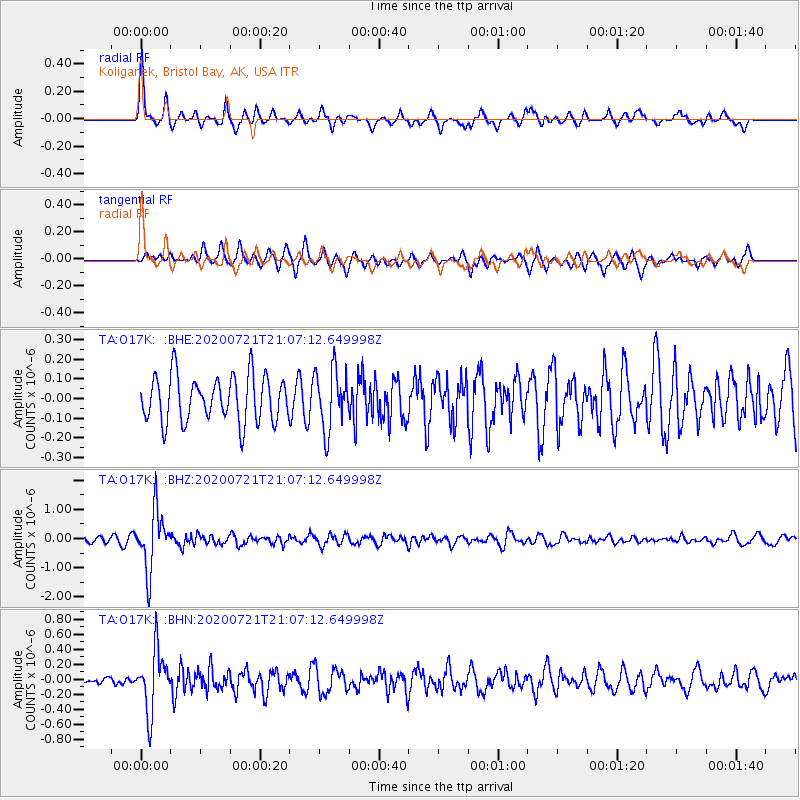
Signal To Noise
| Channel | StoN | STA | LTA |
| TA:O17K: :BHZ:20200721T21:07:12.649998Z | 9.164283 | 1.0048363E-6 | 1.0964702E-7 |
| TA:O17K: :BHN:20200721T21:07:12.649998Z | 5.8789654 | 4.030555E-7 | 6.855892E-8 |
| TA:O17K: :BHE:20200721T21:07:12.649998Z | 1.3210438 | 1.5380624E-7 | 1.16427806E-7 |
| Arrivals |
| Ps | 4.2 SECOND |
| PpPs | 14 SECOND |
| PsPs/PpSs | 19 SECOND |


