You are here: Home > Network List > US - United States National Seismic Network Stations List
> Station HAWA Hanford, Washington, USA > Earthquake Result Viewer
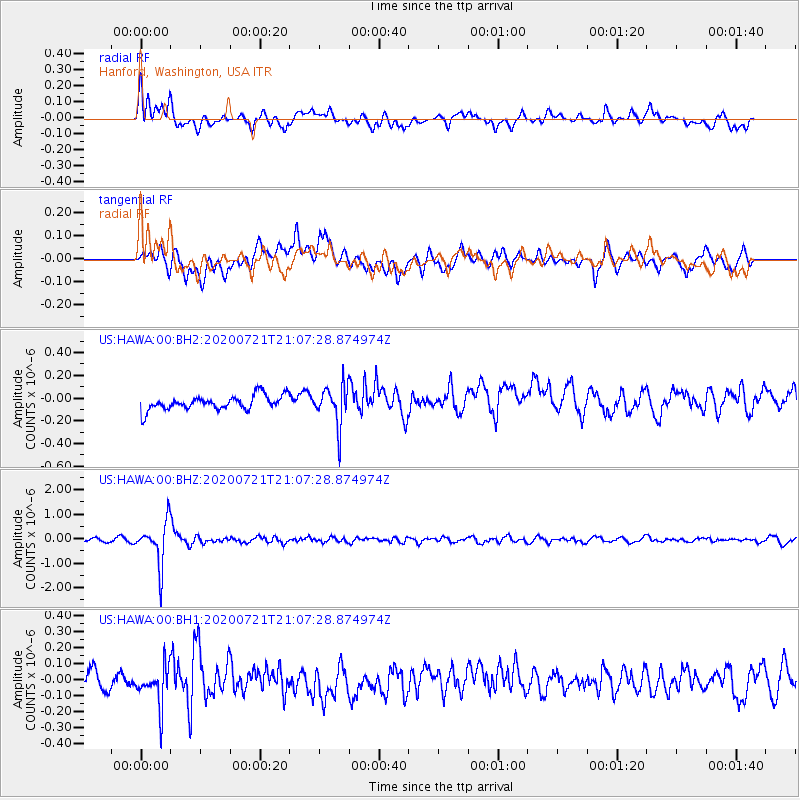
HAWA Hanford, Washington, USA - Earthquake Result Viewer
*The percent match for this event was below the threshold and hence no stack was calculated.
| Earthquake location: |
Fiji Islands Region |
| Earthquake latitude/longitude: |
-20.8/-178.6 |
| Earthquake time(UTC): |
2020/07/21 (203) 20:56:24 GMT |
| Earthquake Depth: |
602 km |
| Earthquake Magnitude: |
6.0 mww |
| Earthquake Catalog/Contributor: |
NEIC PDE/us |
|
| Network: |
US United States National Seismic Network |
| Station: |
HAWA Hanford, Washington, USA |
| Lat/Lon: |
46.39 N/119.53 W |
| Elevation: |
364 m |
|
| Distance: |
85.5 deg |
| Az: |
36.537 deg |
| Baz: |
233.57 deg |
| Ray Param: |
$rayparam |
*The percent match for this event was below the threshold and hence was not used in the summary stack. |
|
| Radial Match: |
75.78881 % |
| Radial Bump: |
400 |
| Transverse Match: |
63.941032 % |
| Transverse Bump: |
400 |
| SOD ConfigId: |
21709731 |
| Insert Time: |
2020-08-04 21:20:25.765 +0000 |
| GWidth: |
2.5 |
| Max Bumps: |
400 |
| Tol: |
0.001 |
|
Signal To Noise
| Channel | StoN | STA | LTA |
| US:HAWA:00:BHZ:20200721T21:07:28.874974Z | 9.523291 | 8.8600007E-7 | 9.303508E-8 |
| US:HAWA:00:BH1:20200721T21:07:28.874974Z | 2.4365332 | 1.2762207E-7 | 5.237855E-8 |
| US:HAWA:00:BH2:20200721T21:07:28.874974Z | 2.7583203 | 1.7493508E-7 | 6.342088E-8 |
| Arrivals |
| Ps | |
| PpPs | |
| PsPs/PpSs | |


