You are here: Home > Network List > US - United States National Seismic Network Stations List
> Station MNTX Cornudas Mountains, Texas, USA > Earthquake Result Viewer
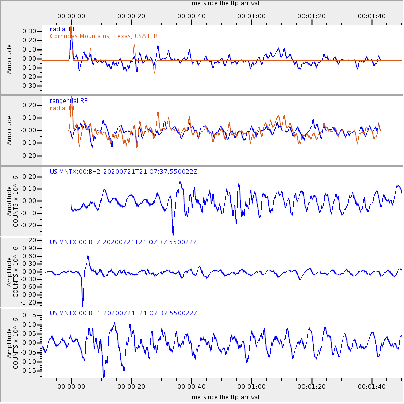
MNTX Cornudas Mountains, Texas, USA - Earthquake Result Viewer
*The percent match for this event was below the threshold and hence no stack was calculated.
| Earthquake location: |
Fiji Islands Region |
| Earthquake latitude/longitude: |
-20.8/-178.6 |
| Earthquake time(UTC): |
2020/07/21 (203) 20:56:24 GMT |
| Earthquake Depth: |
602 km |
| Earthquake Magnitude: |
6.0 mww |
| Earthquake Catalog/Contributor: |
NEIC PDE/us |
|
| Network: |
US United States National Seismic Network |
| Station: |
MNTX Cornudas Mountains, Texas, USA |
| Lat/Lon: |
31.70 N/105.38 W |
| Elevation: |
404 m |
|
| Distance: |
87.4 deg |
| Az: |
54.768 deg |
| Baz: |
243.687 deg |
| Ray Param: |
$rayparam |
*The percent match for this event was below the threshold and hence was not used in the summary stack. |
|
| Radial Match: |
65.66679 % |
| Radial Bump: |
400 |
| Transverse Match: |
69.80894 % |
| Transverse Bump: |
400 |
| SOD ConfigId: |
21709731 |
| Insert Time: |
2020-08-04 21:20:35.716 +0000 |
| GWidth: |
2.5 |
| Max Bumps: |
400 |
| Tol: |
0.001 |
|
Signal To Noise
| Channel | StoN | STA | LTA |
| US:MNTX:00:BHZ:20200721T21:07:37.550022Z | 8.467462 | 3.661306E-7 | 4.323971E-8 |
| US:MNTX:00:BH1:20200721T21:07:37.550022Z | 1.2041055 | 4.2235687E-8 | 3.50764E-8 |
| US:MNTX:00:BH2:20200721T21:07:37.550022Z | 2.1173992 | 8.489645E-8 | 4.0094683E-8 |
| Arrivals |
| Ps | |
| PpPs | |
| PsPs/PpSs | |


