You are here: Home > Network List > AZ - ANZA Regional Network Stations List
> Station SND AZ.SND > Earthquake Result Viewer
SND AZ.SND - Earthquake Result Viewer
| Earthquake location: |
Alaska Peninsula |
| Earthquake latitude/longitude: |
55.2/-158.6 |
| Earthquake time(UTC): |
2020/07/22 (204) 06:12:44 GMT |
| Earthquake Depth: |
13 km |
| Earthquake Magnitude: |
7.4 Mi |
| Earthquake Catalog/Contributor: |
NEIC PDE/at |
|
| Network: |
AZ ANZA Regional Network |
| Station: |
SND AZ.SND |
| Lat/Lon: |
33.55 N/116.61 W |
| Elevation: |
1358 m |
|
| Distance: |
36.2 deg |
| Az: |
109.11 deg |
| Baz: |
319.582 deg |
| Ray Param: |
0.07681101 |
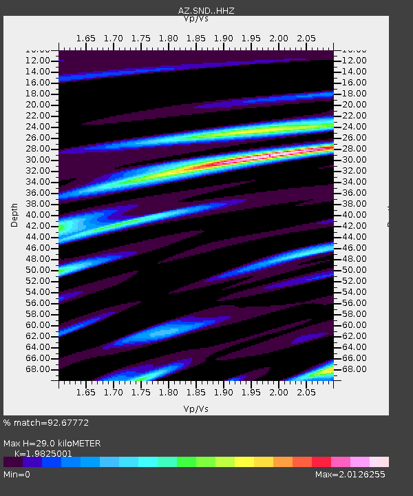
| Estimated Moho Depth: |
29.0 km |
| Estimated Crust Vp/Vs: |
1.98 |
| Assumed Crust Vp: |
6.264 km/s |
| Estimated Crust Vs: |
3.159 km/s |
| Estimated Crust Poisson's Ratio: |
0.33 |
|
| Radial Match: |
92.67772 % |
| Radial Bump: |
323 |
| Transverse Match: |
83.82241 % |
| Transverse Bump: |
400 |
| SOD ConfigId: |
21709731 |
| Insert Time: |
2020-08-05 06:14:44.831 +0000 |
| GWidth: |
2.5 |
| Max Bumps: |
400 |
| Tol: |
0.001 |
|

Signal To Noise
| Channel | StoN | STA | LTA |
| AZ:SND: :HHZ:20200722T06:19:15.847992Z | 19.229618 | 4.2293213E-6 | 2.1993789E-7 |
| AZ:SND: :HHN:20200722T06:19:15.847992Z | 16.817293 | 2.3974812E-6 | 1.4256047E-7 |
| AZ:SND: :HHE:20200722T06:19:15.847992Z | 7.52817 | 1.8363858E-6 | 2.439352E-7 |
| Arrivals |
| Ps | 4.8 SECOND |
| PpPs | 13 SECOND |
| PsPs/PpSs | 18 SECOND |


