You are here: Home > Network List > C0 - Colorado Geological Survey Seismic Network Stations List
> Station T25A Trinidad, CO > Earthquake Result Viewer
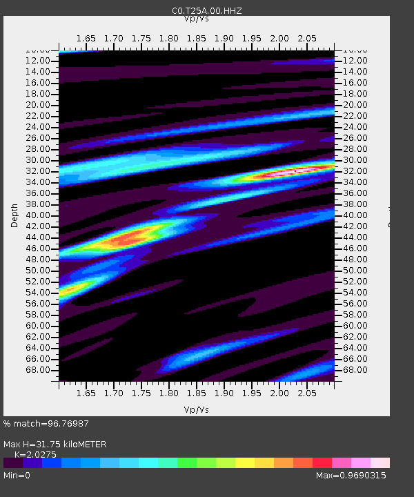
T25A Trinidad, CO - Earthquake Result Viewer
| Earthquake location: |
Alaska Peninsula |
| Earthquake latitude/longitude: |
55.2/-158.6 |
| Earthquake time(UTC): |
2020/07/22 (204) 06:12:44 GMT |
| Earthquake Depth: |
13 km |
| Earthquake Magnitude: |
7.4 Mi |
| Earthquake Catalog/Contributor: |
NEIC PDE/at |
|
| Network: |
C0 Colorado Geological Survey Seismic Network |
| Station: |
T25A Trinidad, CO |
| Lat/Lon: |
37.08 N/104.25 W |
| Elevation: |
1800 m |
|
| Distance: |
40.6 deg |
| Az: |
93.344 deg |
| Baz: |
314.331 deg |
| Ray Param: |
0.07429353 |
| Estimated Moho Depth: |
31.75 km |
| Estimated Crust Vp/Vs: |
2.03 |
| Assumed Crust Vp: |
6.316 km/s |
| Estimated Crust Vs: |
3.115 km/s |
| Estimated Crust Poisson's Ratio: |
0.34 |
|
| Radial Match: |
96.76987 % |
| Radial Bump: |
287 |
| Transverse Match: |
92.95664 % |
| Transverse Bump: |
400 |
| SOD ConfigId: |
21709731 |
| Insert Time: |
2020-08-05 06:15:21.324 +0000 |
| GWidth: |
2.5 |
| Max Bumps: |
400 |
| Tol: |
0.001 |
|

Signal To Noise
| Channel | StoN | STA | LTA |
| C0:T25A:00:HHZ:20200722T06:19:51.450012Z | 15.321849 | 2.5736729E-6 | 1.6797405E-7 |
| C0:T25A:00:HHN:20200722T06:19:51.450012Z | 11.070855 | 1.0221659E-6 | 9.2329444E-8 |
| C0:T25A:00:HHE:20200722T06:19:51.450012Z | 8.024782 | 8.901791E-7 | 1.1092875E-7 |
| Arrivals |
| Ps | 5.5 SECOND |
| PpPs | 14 SECOND |
| PsPs/PpSs | 20 SECOND |


