You are here: Home > Network List > CA - Catalan Seismic Network Stations List
> Station CBRU Bruguera > Earthquake Result Viewer
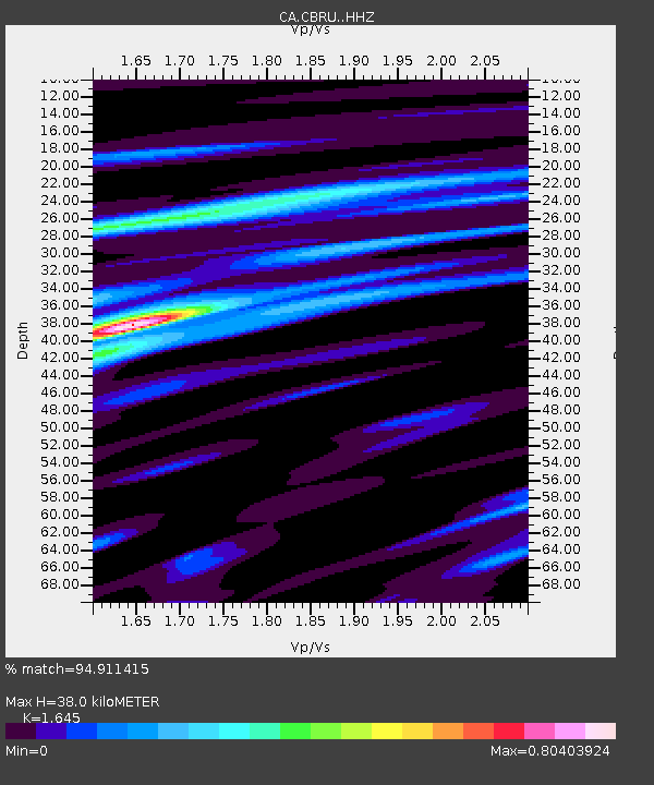
CBRU Bruguera - Earthquake Result Viewer
| Earthquake location: |
Alaska Peninsula |
| Earthquake latitude/longitude: |
55.2/-158.6 |
| Earthquake time(UTC): |
2020/07/22 (204) 06:12:44 GMT |
| Earthquake Depth: |
13 km |
| Earthquake Magnitude: |
7.4 Mi |
| Earthquake Catalog/Contributor: |
NEIC PDE/at |
|
| Network: |
CA Catalan Seismic Network |
| Station: |
CBRU Bruguera |
| Lat/Lon: |
42.28 N/2.18 E |
| Elevation: |
1327 m |
|
| Distance: |
81.5 deg |
| Az: |
14.305 deg |
| Baz: |
349.001 deg |
| Ray Param: |
0.047547318 |
| Estimated Moho Depth: |
38.0 km |
| Estimated Crust Vp/Vs: |
1.64 |
| Assumed Crust Vp: |
6.264 km/s |
| Estimated Crust Vs: |
3.808 km/s |
| Estimated Crust Poisson's Ratio: |
0.21 |
|
| Radial Match: |
94.911415 % |
| Radial Bump: |
400 |
| Transverse Match: |
90.038506 % |
| Transverse Bump: |
400 |
| SOD ConfigId: |
21709731 |
| Insert Time: |
2020-08-05 06:15:31.376 +0000 |
| GWidth: |
2.5 |
| Max Bumps: |
400 |
| Tol: |
0.001 |
|

Signal To Noise
| Channel | StoN | STA | LTA |
| CA:CBRU: :HHZ:20200722T06:24:29.48999Z | 68.99742 | 9.533994E-6 | 1.3817899E-7 |
| CA:CBRU: :HHN:20200722T06:24:29.48999Z | 29.586832 | 2.6689345E-6 | 9.020683E-8 |
| CA:CBRU: :HHE:20200722T06:24:29.48999Z | 10.03748 | 6.515465E-7 | 6.4911355E-8 |
| Arrivals |
| Ps | 4.0 SECOND |
| PpPs | 16 SECOND |
| PsPs/PpSs | 20 SECOND |


