You are here: Home > Network List > CA - Catalan Seismic Network Stations List
> Station CFON Fontmartina > Earthquake Result Viewer
CFON Fontmartina - Earthquake Result Viewer
| Earthquake location: |
Alaska Peninsula |
| Earthquake latitude/longitude: |
55.2/-158.6 |
| Earthquake time(UTC): |
2020/07/22 (204) 06:12:44 GMT |
| Earthquake Depth: |
13 km |
| Earthquake Magnitude: |
7.4 Mi |
| Earthquake Catalog/Contributor: |
NEIC PDE/at |
|
| Network: |
CA Catalan Seismic Network |
| Station: |
CFON Fontmartina |
| Lat/Lon: |
41.76 N/2.43 E |
| Elevation: |
973 m |
|
| Distance: |
82.0 deg |
| Az: |
14.216 deg |
| Baz: |
349.158 deg |
| Ray Param: |
0.04715498 |
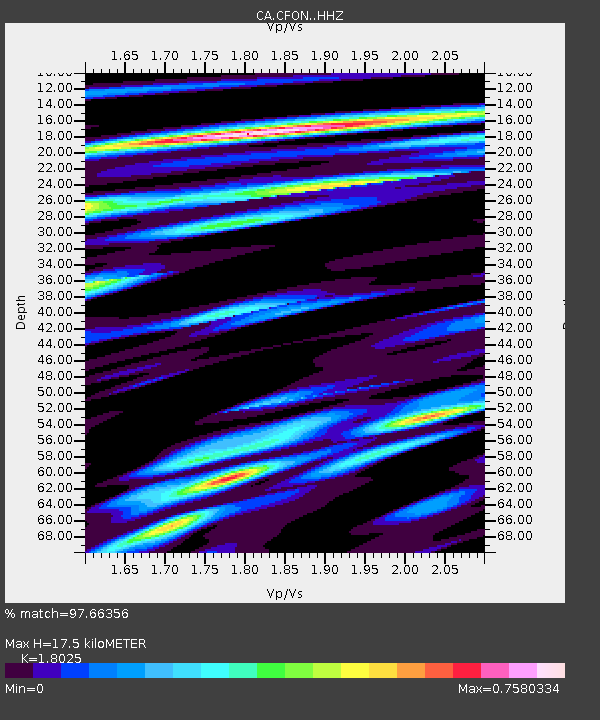
| Estimated Moho Depth: |
17.5 km |
| Estimated Crust Vp/Vs: |
1.80 |
| Assumed Crust Vp: |
5.88 km/s |
| Estimated Crust Vs: |
3.262 km/s |
| Estimated Crust Poisson's Ratio: |
0.28 |
|
| Radial Match: |
97.66356 % |
| Radial Bump: |
400 |
| Transverse Match: |
92.848145 % |
| Transverse Bump: |
400 |
| SOD ConfigId: |
21709731 |
| Insert Time: |
2020-08-05 06:15:37.825 +0000 |
| GWidth: |
2.5 |
| Max Bumps: |
400 |
| Tol: |
0.001 |
|
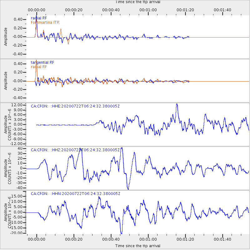
Signal To Noise
| Channel | StoN | STA | LTA |
| CA:CFON: :HHZ:20200722T06:24:32.380005Z | 83.86469 | 1.0428898E-5 | 1.2435387E-7 |
| CA:CFON: :HHN:20200722T06:24:32.380005Z | 46.632908 | 3.6881704E-6 | 7.908943E-8 |
| CA:CFON: :HHE:20200722T06:24:32.380005Z | 21.481232 | 1.3439354E-6 | 6.256324E-8 |
| Arrivals |
| Ps | 2.4 SECOND |
| PpPs | 8.2 SECOND |
| PsPs/PpSs | 11 SECOND |


