You are here: Home > Network List > CA - Catalan Seismic Network Stations List
> Station CLLI Llivia > Earthquake Result Viewer
CLLI Llivia - Earthquake Result Viewer
| Earthquake location: |
Alaska Peninsula |
| Earthquake latitude/longitude: |
55.2/-158.6 |
| Earthquake time(UTC): |
2020/07/22 (204) 06:12:44 GMT |
| Earthquake Depth: |
13 km |
| Earthquake Magnitude: |
7.4 Mi |
| Earthquake Catalog/Contributor: |
NEIC PDE/at |
|
| Network: |
CA Catalan Seismic Network |
| Station: |
CLLI Llivia |
| Lat/Lon: |
42.48 N/1.97 E |
| Elevation: |
1413 m |
|
| Distance: |
81.3 deg |
| Az: |
14.419 deg |
| Baz: |
348.879 deg |
| Ray Param: |
0.047701254 |
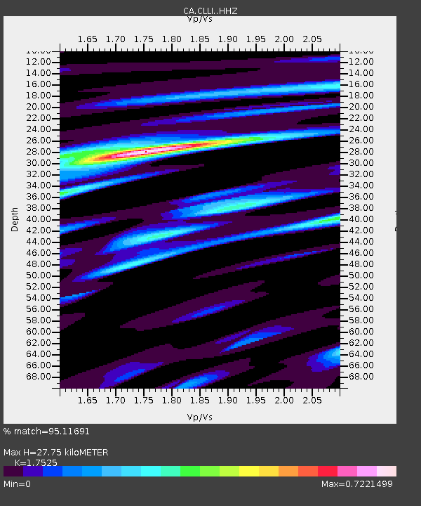
| Estimated Moho Depth: |
27.75 km |
| Estimated Crust Vp/Vs: |
1.75 |
| Assumed Crust Vp: |
6.416 km/s |
| Estimated Crust Vs: |
3.661 km/s |
| Estimated Crust Poisson's Ratio: |
0.26 |
|
| Radial Match: |
95.11691 % |
| Radial Bump: |
400 |
| Transverse Match: |
89.941246 % |
| Transverse Bump: |
400 |
| SOD ConfigId: |
21709731 |
| Insert Time: |
2020-08-05 06:15:40.762 +0000 |
| GWidth: |
2.5 |
| Max Bumps: |
400 |
| Tol: |
0.001 |
|

Signal To Noise
| Channel | StoN | STA | LTA |
| CA:CLLI: :HHZ:20200722T06:24:28.330017Z | 58.404503 | 8.576187E-6 | 1.4684119E-7 |
| CA:CLLI: :HHN:20200722T06:24:28.330017Z | 31.48212 | 2.8547106E-6 | 9.0677204E-8 |
| CA:CLLI: :HHE:20200722T06:24:28.330017Z | 22.457163 | 1.2842684E-6 | 5.718747E-8 |
| Arrivals |
| Ps | 3.3 SECOND |
| PpPs | 12 SECOND |
| PsPs/PpSs | 15 SECOND |


