You are here: Home > Network List > CA - Catalan Seismic Network Stations List
> Station EBR Ebre > Earthquake Result Viewer
EBR Ebre - Earthquake Result Viewer
| Earthquake location: |
Alaska Peninsula |
| Earthquake latitude/longitude: |
55.2/-158.6 |
| Earthquake time(UTC): |
2020/07/22 (204) 06:12:44 GMT |
| Earthquake Depth: |
13 km |
| Earthquake Magnitude: |
7.4 Mi |
| Earthquake Catalog/Contributor: |
NEIC PDE/at |
|
| Network: |
CA Catalan Seismic Network |
| Station: |
EBR Ebre |
| Lat/Lon: |
40.82 N/0.49 E |
| Elevation: |
36 m |
|
| Distance: |
82.7 deg |
| Az: |
15.85 deg |
| Baz: |
348.1 deg |
| Ray Param: |
0.046720274 |
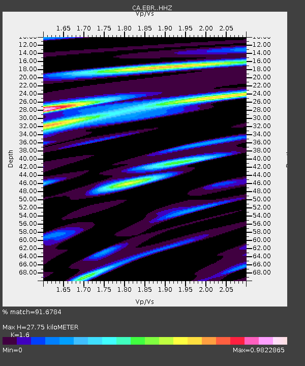
| Estimated Moho Depth: |
27.75 km |
| Estimated Crust Vp/Vs: |
1.60 |
| Assumed Crust Vp: |
6.391 km/s |
| Estimated Crust Vs: |
3.994 km/s |
| Estimated Crust Poisson's Ratio: |
0.18 |
|
| Radial Match: |
91.6784 % |
| Radial Bump: |
400 |
| Transverse Match: |
70.97726 % |
| Transverse Bump: |
400 |
| SOD ConfigId: |
21709731 |
| Insert Time: |
2020-08-05 06:15:49.971 +0000 |
| GWidth: |
2.5 |
| Max Bumps: |
400 |
| Tol: |
0.001 |
|
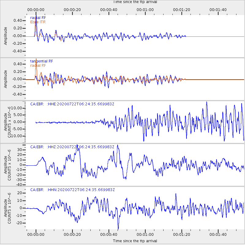
Signal To Noise
| Channel | StoN | STA | LTA |
| CA:EBR: :HHZ:20200722T06:24:35.669983Z | 45.87671 | 9.06181E-6 | 1.9752527E-7 |
| CA:EBR: :HHN:20200722T06:24:35.669983Z | 15.739157 | 3.5645921E-6 | 2.2647924E-7 |
| CA:EBR: :HHE:20200722T06:24:35.669983Z | 2.6445916 | 5.327209E-7 | 2.0143786E-7 |
| Arrivals |
| Ps | 2.7 SECOND |
| PpPs | 11 SECOND |
| PsPs/PpSs | 14 SECOND |


