You are here: Home > Network List > CI - Caltech Regional Seismic Network Stations List
> Station CIA CIA, Avalon Catalina Island, CA, USA > Earthquake Result Viewer
CIA CIA, Avalon Catalina Island, CA, USA - Earthquake Result Viewer
| Earthquake location: |
Alaska Peninsula |
| Earthquake latitude/longitude: |
55.2/-158.6 |
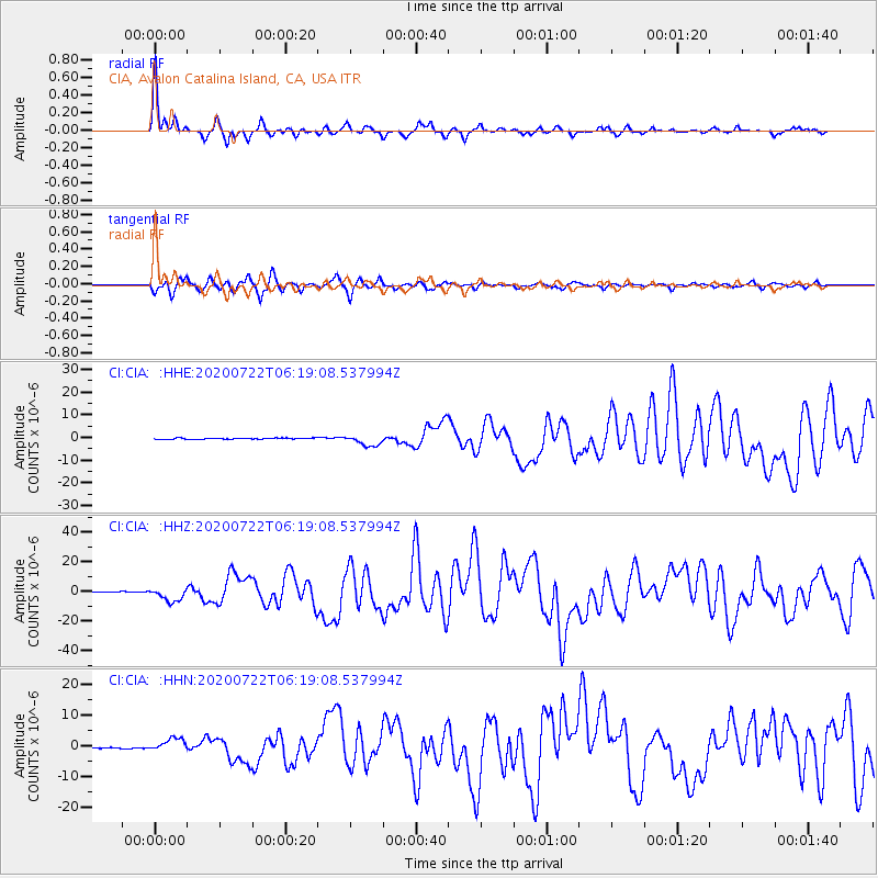
| Earthquake time(UTC): |
2020/07/22 (204) 06:12:44 GMT |
| Earthquake Depth: |
13 km |
| Earthquake Magnitude: |
7.4 Mi |
| Earthquake Catalog/Contributor: |
NEIC PDE/at |
|
| Network: |
CI Caltech Regional Seismic Network |
| Station: |
CIA CIA, Avalon Catalina Island, CA, USA |
| Lat/Lon: |
33.40 N/118.41 W |
| Elevation: |
467 m |
|
| Distance: |
35.4 deg |
| Az: |
111.244 deg |
| Baz: |
320.324 deg |
| Ray Param: |
0.077245444 |
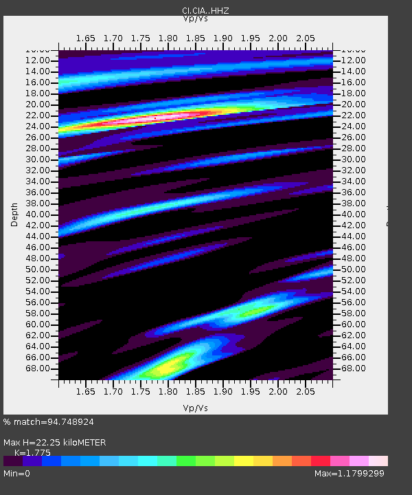
| Estimated Moho Depth: |
22.25 km |
| Estimated Crust Vp/Vs: |
1.77 |
| Assumed Crust Vp: |
6.048 km/s |
| Estimated Crust Vs: |
3.407 km/s |
| Estimated Crust Poisson's Ratio: |
0.27 |
|
| Radial Match: |
94.748924 % |
| Radial Bump: |
266 |
| Transverse Match: |
87.90765 % |
| Transverse Bump: |
370 |
| SOD ConfigId: |
21709731 |
| Insert Time: |
2020-08-05 06:16:23.096 +0000 |
| GWidth: |
2.5 |
| Max Bumps: |
400 |
| Tol: |
0.001 |
|
Signal To Noise
| Channel | StoN | STA | LTA |
| CI:CIA: :HHZ:20200722T06:19:08.537994Z | 14.867146 | 4.5422876E-6 | 3.055252E-7 |
| CI:CIA: :HHN:20200722T06:19:08.537994Z | 11.257733 | 2.1109893E-6 | 1.8751459E-7 |
| CI:CIA: :HHE:20200722T06:19:08.537994Z | 9.246063 | 2.4289513E-6 | 2.6270115E-7 |
| Arrivals |
| Ps | 3.0 SECOND |
| PpPs | 9.6 SECOND |
| PsPs/PpSs | 13 SECOND |


