You are here: Home > Network List > CI - Caltech Regional Seismic Network Stations List
> Station GLA Glamis, Glamis, CA, USA > Earthquake Result Viewer
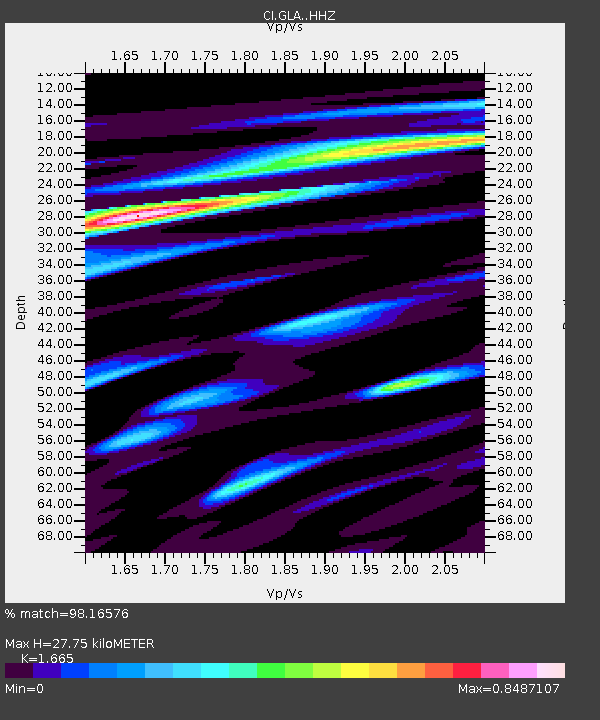
GLA Glamis, Glamis, CA, USA - Earthquake Result Viewer
| Earthquake location: |
Alaska Peninsula |
| Earthquake latitude/longitude: |
55.2/-158.6 |
| Earthquake time(UTC): |
2020/07/22 (204) 06:12:44 GMT |
| Earthquake Depth: |
13 km |
| Earthquake Magnitude: |
7.4 Mi |
| Earthquake Catalog/Contributor: |
NEIC PDE/at |
|
| Network: |
CI Caltech Regional Seismic Network |
| Station: |
GLA Glamis, Glamis, CA, USA |
| Lat/Lon: |
33.05 N/114.83 W |
| Elevation: |
610 m |
|
| Distance: |
37.6 deg |
| Az: |
107.755 deg |
| Baz: |
319.475 deg |
| Ray Param: |
0.0760467 |
| Estimated Moho Depth: |
27.75 km |
| Estimated Crust Vp/Vs: |
1.66 |
| Assumed Crust Vp: |
6.155 km/s |
| Estimated Crust Vs: |
3.696 km/s |
| Estimated Crust Poisson's Ratio: |
0.22 |
|
| Radial Match: |
98.16576 % |
| Radial Bump: |
311 |
| Transverse Match: |
94.27993 % |
| Transverse Bump: |
400 |
| SOD ConfigId: |
21709731 |
| Insert Time: |
2020-08-05 06:16:42.029 +0000 |
| GWidth: |
2.5 |
| Max Bumps: |
400 |
| Tol: |
0.001 |
|

Signal To Noise
| Channel | StoN | STA | LTA |
| CI:GLA: :HHZ:20200722T06:19:27.308014Z | 18.595135 | 3.9639717E-6 | 2.1317253E-7 |
| CI:GLA: :HHN:20200722T06:19:27.308014Z | 15.531986 | 1.7814403E-6 | 1.1469495E-7 |
| CI:GLA: :HHE:20200722T06:19:27.308014Z | 11.483508 | 1.6192416E-6 | 1.4100583E-7 |
| Arrivals |
| Ps | 3.2 SECOND |
| PpPs | 11 SECOND |
| PsPs/PpSs | 14 SECOND |


