You are here: Home > Network List > CI - Caltech Regional Seismic Network Stations List
> Station HEC Hector, Baker, CA, USA > Earthquake Result Viewer
HEC Hector, Baker, CA, USA - Earthquake Result Viewer
| Earthquake location: |
Alaska Peninsula |
| Earthquake latitude/longitude: |
55.2/-158.6 |
| Earthquake time(UTC): |
2020/07/22 (204) 06:12:44 GMT |
| Earthquake Depth: |
13 km |
| Earthquake Magnitude: |
7.4 Mi |
| Earthquake Catalog/Contributor: |
NEIC PDE/at |
|
| Network: |
CI Caltech Regional Seismic Network |
| Station: |
HEC Hector, Baker, CA, USA |
| Lat/Lon: |
34.83 N/116.33 W |
| Elevation: |
920 m |
|
| Distance: |
35.4 deg |
| Az: |
107.384 deg |
| Baz: |
318.338 deg |
| Ray Param: |
0.07722259 |
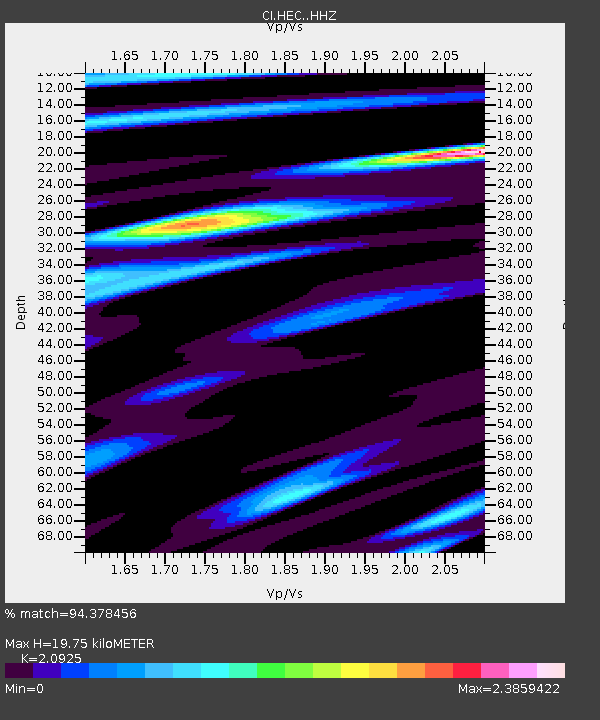
| Estimated Moho Depth: |
19.75 km |
| Estimated Crust Vp/Vs: |
2.09 |
| Assumed Crust Vp: |
6.276 km/s |
| Estimated Crust Vs: |
2.999 km/s |
| Estimated Crust Poisson's Ratio: |
0.35 |
|
| Radial Match: |
94.378456 % |
| Radial Bump: |
400 |
| Transverse Match: |
87.18283 % |
| Transverse Bump: |
400 |
| SOD ConfigId: |
21709731 |
| Insert Time: |
2020-08-05 06:16:47.250 +0000 |
| GWidth: |
2.5 |
| Max Bumps: |
400 |
| Tol: |
0.001 |
|

Signal To Noise
| Channel | StoN | STA | LTA |
| CI:HEC: :HHZ:20200722T06:19:08.917999Z | 19.239908 | 3.7863163E-6 | 1.9679493E-7 |
| CI:HEC: :HHN:20200722T06:19:08.917999Z | 9.780476 | 1.506319E-6 | 1.5401285E-7 |
| CI:HEC: :HHE:20200722T06:19:08.917999Z | 11.544794 | 1.7613085E-6 | 1.52563E-7 |
| Arrivals |
| Ps | 3.7 SECOND |
| PpPs | 9.2 SECOND |
| PsPs/PpSs | 13 SECOND |


