You are here: Home > Network List > CI - Caltech Regional Seismic Network Stations List
> Station MPP McPhearson Peak > Earthquake Result Viewer
MPP McPhearson Peak - Earthquake Result Viewer
| Earthquake location: |
Alaska Peninsula |
| Earthquake latitude/longitude: |
55.2/-158.6 |
| Earthquake time(UTC): |
2020/07/22 (204) 06:12:44 GMT |
| Earthquake Depth: |
13 km |
| Earthquake Magnitude: |
7.4 Mi |
| Earthquake Catalog/Contributor: |
NEIC PDE/at |
|
| Network: |
CI Caltech Regional Seismic Network |
| Station: |
MPP McPhearson Peak |
| Lat/Lon: |
34.89 N/119.81 W |
| Elevation: |
1739 m |
|
| Distance: |
33.5 deg |
| Az: |
111.124 deg |
| Baz: |
319.443 deg |
| Ray Param: |
0.078187875 |
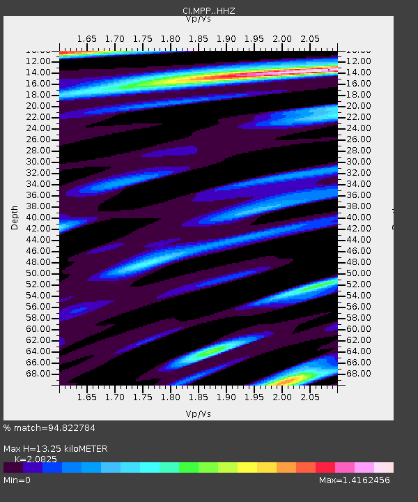
| Estimated Moho Depth: |
13.25 km |
| Estimated Crust Vp/Vs: |
2.08 |
| Assumed Crust Vp: |
6.1 km/s |
| Estimated Crust Vs: |
2.929 km/s |
| Estimated Crust Poisson's Ratio: |
0.35 |
|
| Radial Match: |
94.822784 % |
| Radial Bump: |
400 |
| Transverse Match: |
88.069954 % |
| Transverse Bump: |
400 |
| SOD ConfigId: |
21709731 |
| Insert Time: |
2020-08-05 06:17:04.692 +0000 |
| GWidth: |
2.5 |
| Max Bumps: |
400 |
| Tol: |
0.001 |
|
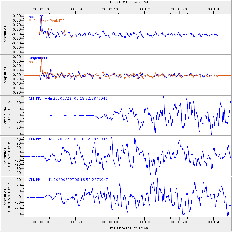
Signal To Noise
| Channel | StoN | STA | LTA |
| CI:MPP: :HHZ:20200722T06:18:52.287994Z | 26.232513 | 5.378689E-6 | 2.0503903E-7 |
| CI:MPP: :HHN:20200722T06:18:52.287994Z | 9.128407 | 2.5351012E-6 | 2.7771563E-7 |
| CI:MPP: :HHE:20200722T06:18:52.287994Z | 15.311101 | 2.4116646E-6 | 1.5751084E-7 |
| Arrivals |
| Ps | 2.5 SECOND |
| PpPs | 6.3 SECOND |
| PsPs/PpSs | 8.8 SECOND |


