You are here: Home > Network List > CI - Caltech Regional Seismic Network Stations List
> Station SDD Saddleback, Mission Viejo, CA, USA > Earthquake Result Viewer
SDD Saddleback, Mission Viejo, CA, USA - Earthquake Result Viewer

| Earthquake location: |
Alaska Peninsula |
| Earthquake latitude/longitude: |
55.2/-158.6 |
| Earthquake time(UTC): |
2020/07/22 (204) 06:12:44 GMT |
| Earthquake Depth: |
13 km |
| Earthquake Magnitude: |
7.4 Mi |
| Earthquake Catalog/Contributor: |
NEIC PDE/at |
|
| Network: |
CI Caltech Regional Seismic Network |
| Station: |
SDD Saddleback, Mission Viejo, CA, USA |
| Lat/Lon: |
33.55 N/117.66 W |
| Elevation: |
120 m |
|
| Distance: |
35.7 deg |
| Az: |
110.248 deg |
| Baz: |
319.926 deg |
| Ray Param: |
0.0770908 |
| Estimated Moho Depth: |
66.0 km |
| Estimated Crust Vp/Vs: |
2.05 |
| Assumed Crust Vp: |
6.264 km/s |
| Estimated Crust Vs: |
3.055 km/s |
| Estimated Crust Poisson's Ratio: |
0.34 |
|
| Radial Match: |
85.34117 % |
| Radial Bump: |
400 |
| Transverse Match: |
92.372734 % |
| Transverse Bump: |
392 |
| SOD ConfigId: |
21709731 |
| Insert Time: |
2020-08-05 06:17:28.241 +0000 |
| GWidth: |
2.5 |
| Max Bumps: |
400 |
| Tol: |
0.001 |
|
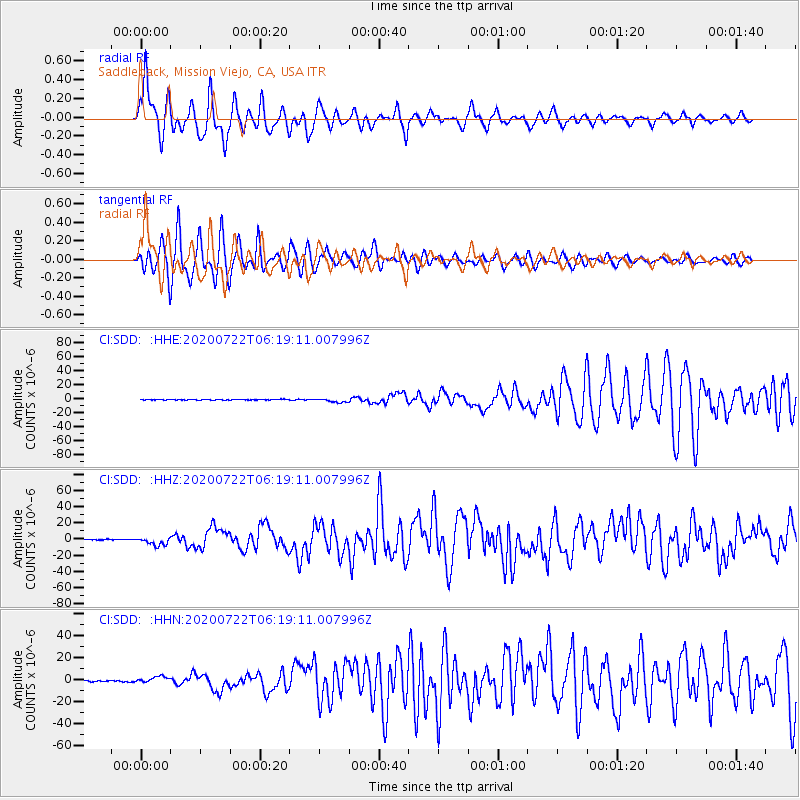
Signal To Noise
| Channel | StoN | STA | LTA |
| CI:SDD: :HHZ:20200722T06:19:11.007996Z | 12.073484 | 5.005332E-6 | 4.1457224E-7 |
| CI:SDD: :HHN:20200722T06:19:11.007996Z | 6.4616094 | 2.826336E-6 | 4.3740434E-7 |
| CI:SDD: :HHE:20200722T06:19:11.007996Z | 5.6560273 | 2.7428637E-6 | 4.8494525E-7 |
| Arrivals |
| Ps | 12 SECOND |
| PpPs | 30 SECOND |
| PsPs/PpSs | 42 SECOND |


