You are here: Home > Network List > CI - Caltech Regional Seismic Network Stations List
> Station VTV Victorville, California, USA > Earthquake Result Viewer
VTV Victorville, California, USA - Earthquake Result Viewer
| Earthquake location: |
Alaska Peninsula |
| Earthquake latitude/longitude: |
55.2/-158.6 |
| Earthquake time(UTC): |
2020/07/22 (204) 06:12:44 GMT |
| Earthquake Depth: |
13 km |
| Earthquake Magnitude: |
7.4 Mi |
| Earthquake Catalog/Contributor: |
NEIC PDE/at |
|
| Network: |
CI Caltech Regional Seismic Network |
| Station: |
VTV Victorville, California, USA |
| Lat/Lon: |
34.56 N/117.33 W |
| Elevation: |
812 m |
|
| Distance: |
35.1 deg |
| Az: |
108.756 deg |
| Baz: |
318.895 deg |
| Ray Param: |
0.077404596 |
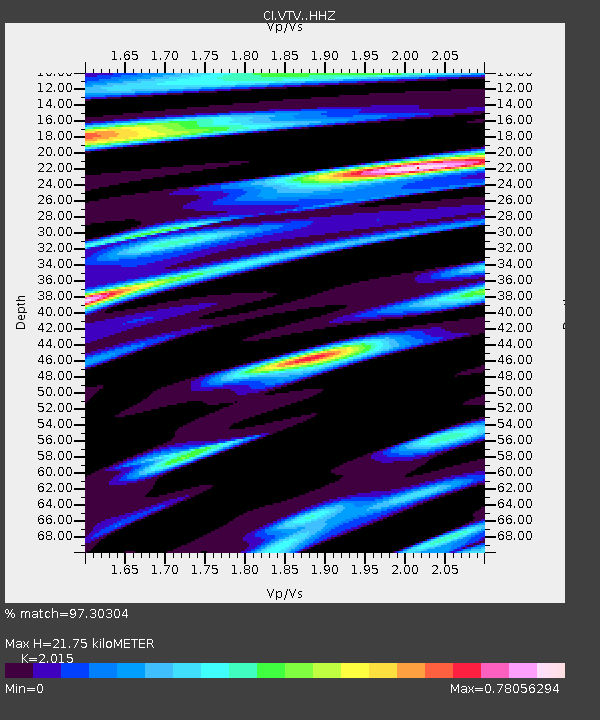
| Estimated Moho Depth: |
21.75 km |
| Estimated Crust Vp/Vs: |
2.02 |
| Assumed Crust Vp: |
6.276 km/s |
| Estimated Crust Vs: |
3.115 km/s |
| Estimated Crust Poisson's Ratio: |
0.34 |
|
| Radial Match: |
97.30304 % |
| Radial Bump: |
274 |
| Transverse Match: |
89.39448 % |
| Transverse Bump: |
400 |
| SOD ConfigId: |
21709731 |
| Insert Time: |
2020-08-05 06:17:49.580 +0000 |
| GWidth: |
2.5 |
| Max Bumps: |
400 |
| Tol: |
0.001 |
|

Signal To Noise
| Channel | StoN | STA | LTA |
| CI:VTV: :HHZ:20200722T06:19:05.988007Z | 14.256053 | 4.12534E-6 | 2.8937467E-7 |
| CI:VTV: :HHN:20200722T06:19:05.988007Z | 7.2542644 | 2.5545176E-6 | 3.5214012E-7 |
| CI:VTV: :HHE:20200722T06:19:05.988007Z | 6.3464313 | 2.3891212E-6 | 3.7645114E-7 |
| Arrivals |
| Ps | 3.7 SECOND |
| PpPs | 9.8 SECOND |
| PsPs/PpSs | 14 SECOND |


