You are here: Home > Network List > CN - Canadian National Seismograph Network Stations List
> Station BLKN Baker Lake, NU, CA > Earthquake Result Viewer
BLKN Baker Lake, NU, CA - Earthquake Result Viewer
| Earthquake location: |
Alaska Peninsula |
| Earthquake latitude/longitude: |
55.2/-158.6 |
| Earthquake time(UTC): |
2020/07/22 (204) 06:12:44 GMT |
| Earthquake Depth: |
13 km |
| Earthquake Magnitude: |
7.4 Mi |
| Earthquake Catalog/Contributor: |
NEIC PDE/at |
|
| Network: |
CN Canadian National Seismograph Network |
| Station: |
BLKN Baker Lake, NU, CA |
| Lat/Lon: |
64.32 N/96.00 W |
| Elevation: |
40 m |
|
| Distance: |
31.5 deg |
| Az: |
47.75 deg |
| Baz: |
283.24 deg |
| Ray Param: |
0.079044975 |
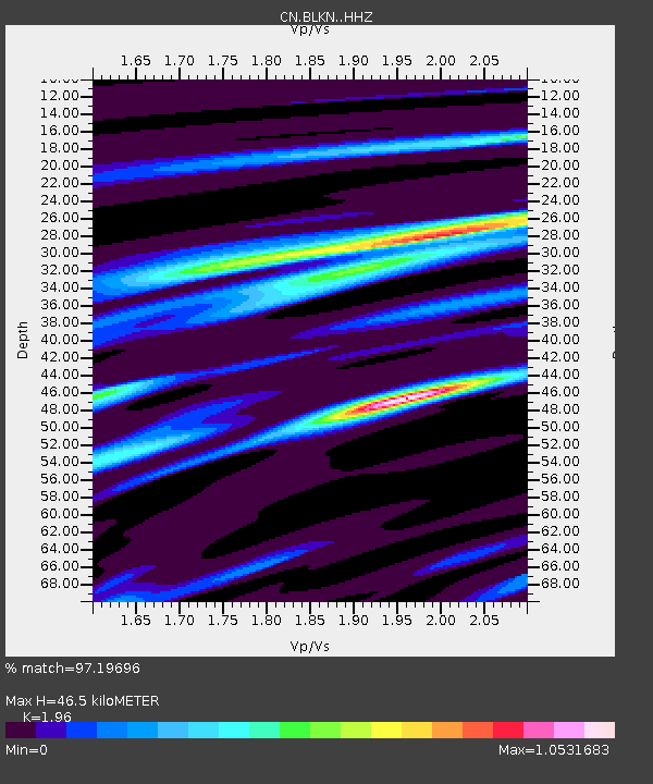
| Estimated Moho Depth: |
46.5 km |
| Estimated Crust Vp/Vs: |
1.96 |
| Assumed Crust Vp: |
6.459 km/s |
| Estimated Crust Vs: |
3.296 km/s |
| Estimated Crust Poisson's Ratio: |
0.32 |
|
| Radial Match: |
97.19696 % |
| Radial Bump: |
242 |
| Transverse Match: |
87.00655 % |
| Transverse Bump: |
400 |
| SOD ConfigId: |
21709731 |
| Insert Time: |
2020-08-05 06:18:11.644 +0000 |
| GWidth: |
2.5 |
| Max Bumps: |
400 |
| Tol: |
0.001 |
|

Signal To Noise
| Channel | StoN | STA | LTA |
| CN:BLKN: :HHZ:20200722T06:18:34.839996Z | 49.89118 | 8.786754E-6 | 1.7611839E-7 |
| CN:BLKN: :HHN:20200722T06:18:34.839996Z | 16.018433 | 1.9633126E-6 | 1.2256585E-7 |
| CN:BLKN: :HHE:20200722T06:18:34.839996Z | 35.256176 | 5.6197664E-6 | 1.5939806E-7 |
| Arrivals |
| Ps | 7.4 SECOND |
| PpPs | 20 SECOND |
| PsPs/PpSs | 27 SECOND |


