You are here: Home > Network List > CN - Canadian National Seismograph Network Stations List
> Station PMAQ Port Menier Anticosti Is, QC, CA > Earthquake Result Viewer
PMAQ Port Menier Anticosti Is, QC, CA - Earthquake Result Viewer
| Earthquake location: |
Alaska Peninsula |
| Earthquake latitude/longitude: |
55.2/-158.6 |
| Earthquake time(UTC): |
2020/07/22 (204) 06:12:44 GMT |
| Earthquake Depth: |
13 km |
| Earthquake Magnitude: |
7.4 Mi |
| Earthquake Catalog/Contributor: |
NEIC PDE/at |
|
| Network: |
CN Canadian National Seismograph Network |
| Station: |
PMAQ Port Menier Anticosti Is, QC, CA |
| Lat/Lon: |
49.83 N/64.33 W |
| Elevation: |
25 m |
|
| Distance: |
53.4 deg |
| Az: |
53.601 deg |
| Baz: |
314.586 deg |
| Ray Param: |
0.066162236 |
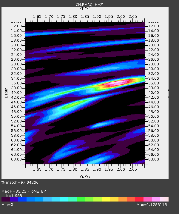
| Estimated Moho Depth: |
35.25 km |
| Estimated Crust Vp/Vs: |
1.99 |
| Assumed Crust Vp: |
6.35 km/s |
| Estimated Crust Vs: |
3.199 km/s |
| Estimated Crust Poisson's Ratio: |
0.33 |
|
| Radial Match: |
97.64206 % |
| Radial Bump: |
210 |
| Transverse Match: |
87.19409 % |
| Transverse Bump: |
400 |
| SOD ConfigId: |
21709731 |
| Insert Time: |
2020-08-05 06:18:55.898 +0000 |
| GWidth: |
2.5 |
| Max Bumps: |
400 |
| Tol: |
0.001 |
|

Signal To Noise
| Channel | StoN | STA | LTA |
| CN:PMAQ: :HHZ:20200722T06:21:31.919983Z | 19.266222 | 6.6864877E-6 | 3.4705755E-7 |
| CN:PMAQ: :HHN:20200722T06:21:31.919983Z | 10.566602 | 2.2438928E-6 | 2.123571E-7 |
| CN:PMAQ: :HHE:20200722T06:21:31.919983Z | 15.365908 | 3.1748914E-6 | 2.0661919E-7 |
| Arrivals |
| Ps | 5.7 SECOND |
| PpPs | 16 SECOND |
| PsPs/PpSs | 22 SECOND |


