You are here: Home > Network List > EC - Ecuador Seismic Network Stations List
> Station SLOR TEMP - COTO > Earthquake Result Viewer
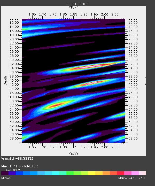
SLOR TEMP - COTO - Earthquake Result Viewer
| Earthquake location: |
Alaska Peninsula |
| Earthquake latitude/longitude: |
55.2/-158.6 |
| Earthquake time(UTC): |
2020/07/22 (204) 06:12:44 GMT |
| Earthquake Depth: |
13 km |
| Earthquake Magnitude: |
7.4 Mi |
| Earthquake Catalog/Contributor: |
NEIC PDE/at |
|
| Network: |
EC Ecuador Seismic Network |
| Station: |
SLOR TEMP - COTO |
| Lat/Lon: |
0.73 S/78.50 W |
| Elevation: |
3600 m |
|
| Distance: |
84.9 deg |
| Az: |
98.555 deg |
| Baz: |
325.481 deg |
| Ray Param: |
0.04512086 |
| Estimated Moho Depth: |
41.0 km |
| Estimated Crust Vp/Vs: |
1.94 |
| Assumed Crust Vp: |
6.472 km/s |
| Estimated Crust Vs: |
3.341 km/s |
| Estimated Crust Poisson's Ratio: |
0.32 |
|
| Radial Match: |
88.53852 % |
| Radial Bump: |
400 |
| Transverse Match: |
75.86869 % |
| Transverse Bump: |
400 |
| SOD ConfigId: |
21709731 |
| Insert Time: |
2020-08-05 06:20:20.901 +0000 |
| GWidth: |
2.5 |
| Max Bumps: |
400 |
| Tol: |
0.001 |
|

Signal To Noise
| Channel | StoN | STA | LTA |
| EC:SLOR: :HHZ:20200722T06:24:47.205017Z | 15.680974 | 6.0029396E-7 | 3.8281676E-8 |
| EC:SLOR: :HHN:20200722T06:24:47.205017Z | 4.6951523 | 2.5489615E-7 | 5.4289217E-8 |
| EC:SLOR: :HHE:20200722T06:24:47.205017Z | 3.347286 | 1.9019353E-7 | 5.6820223E-8 |
| Arrivals |
| Ps | 6.1 SECOND |
| PpPs | 18 SECOND |
| PsPs/PpSs | 24 SECOND |


