You are here: Home > Network List > EI - Irish National Seismic Network (INSN) Stations List
> Station IWEX CARRICKBYRNE, CO WEXFORD > Earthquake Result Viewer
IWEX CARRICKBYRNE, CO WEXFORD - Earthquake Result Viewer
| Earthquake location: |
Alaska Peninsula |
| Earthquake latitude/longitude: |
55.2/-158.6 |
| Earthquake time(UTC): |
2020/07/22 (204) 06:12:44 GMT |
| Earthquake Depth: |
13 km |
| Earthquake Magnitude: |
7.4 Mi |
| Earthquake Catalog/Contributor: |
NEIC PDE/at |
|
| Network: |
EI Irish National Seismic Network (INSN) |
| Station: |
IWEX CARRICKBYRNE, CO WEXFORD |
| Lat/Lon: |
52.37 N/6.77 W |
| Elevation: |
180 m |
|
| Distance: |
70.3 deg |
| Az: |
17.915 deg |
| Baz: |
343.291 deg |
| Ray Param: |
0.055114247 |
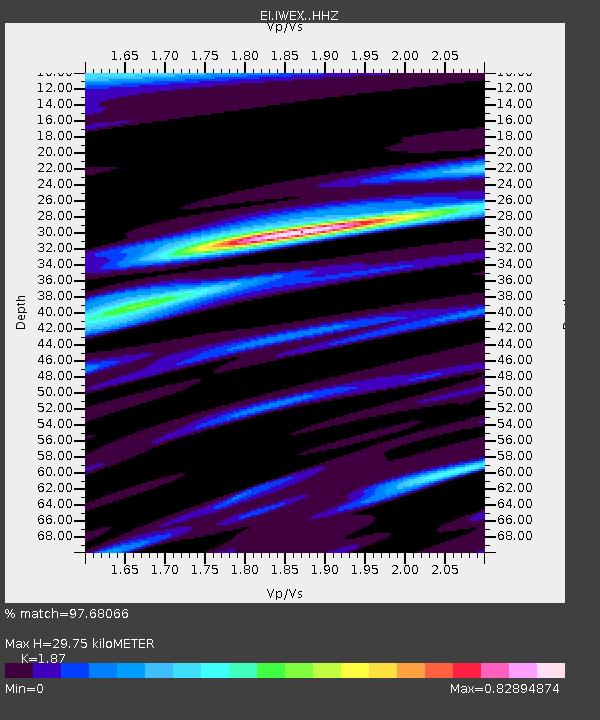
| Estimated Moho Depth: |
29.75 km |
| Estimated Crust Vp/Vs: |
1.87 |
| Assumed Crust Vp: |
6.276 km/s |
| Estimated Crust Vs: |
3.356 km/s |
| Estimated Crust Poisson's Ratio: |
0.30 |
|
| Radial Match: |
97.68066 % |
| Radial Bump: |
374 |
| Transverse Match: |
91.3632 % |
| Transverse Bump: |
400 |
| SOD ConfigId: |
21709731 |
| Insert Time: |
2020-08-05 06:20:30.059 +0000 |
| GWidth: |
2.5 |
| Max Bumps: |
400 |
| Tol: |
0.001 |
|

Signal To Noise
| Channel | StoN | STA | LTA |
| EI:IWEX: :HHZ:20200722T06:23:25.51001Z | 44.62447 | 1.1983749E-5 | 2.685466E-7 |
| EI:IWEX: :HHN:20200722T06:23:25.51001Z | 26.638351 | 5.469272E-6 | 2.053157E-7 |
| EI:IWEX: :HHE:20200722T06:23:25.51001Z | 14.030271 | 2.0278644E-6 | 1.4453495E-7 |
| Arrivals |
| Ps | 4.3 SECOND |
| PpPs | 13 SECOND |
| PsPs/PpSs | 17 SECOND |


