You are here: Home > Network List > ET - CERI Southern Appalachian seismic Network Stations List
> Station GFM Grandfather Mountain,NC > Earthquake Result Viewer
GFM Grandfather Mountain,NC - Earthquake Result Viewer
| Earthquake location: |
Alaska Peninsula |
| Earthquake latitude/longitude: |
55.2/-158.6 |
| Earthquake time(UTC): |
2020/07/22 (204) 06:12:44 GMT |
| Earthquake Depth: |
13 km |
| Earthquake Magnitude: |
7.4 Mi |
| Earthquake Catalog/Contributor: |
NEIC PDE/at |
|
| Network: |
ET CERI Southern Appalachian seismic Network |
| Station: |
GFM Grandfather Mountain,NC |
| Lat/Lon: |
36.11 N/81.81 W |
| Elevation: |
1726 m |
|
| Distance: |
54.1 deg |
| Az: |
76.825 deg |
| Baz: |
316.448 deg |
| Ray Param: |
0.06567984 |
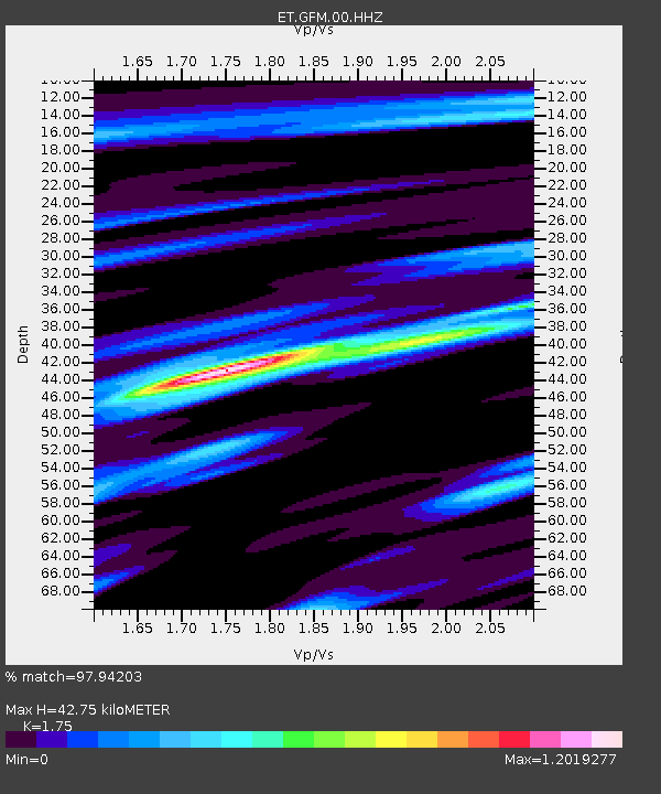
| Estimated Moho Depth: |
42.75 km |
| Estimated Crust Vp/Vs: |
1.75 |
| Assumed Crust Vp: |
6.159 km/s |
| Estimated Crust Vs: |
3.519 km/s |
| Estimated Crust Poisson's Ratio: |
0.26 |
|
| Radial Match: |
97.94203 % |
| Radial Bump: |
282 |
| Transverse Match: |
92.19556 % |
| Transverse Bump: |
400 |
| SOD ConfigId: |
21709731 |
| Insert Time: |
2020-08-05 06:20:37.745 +0000 |
| GWidth: |
2.5 |
| Max Bumps: |
400 |
| Tol: |
0.001 |
|

Signal To Noise
| Channel | StoN | STA | LTA |
| ET:GFM:00:HHZ:20200722T06:21:37.080017Z | 31.332485 | 3.4615018E-6 | 1.1047645E-7 |
| ET:GFM:00:HHN:20200722T06:21:37.080017Z | 8.940313 | 1.431628E-6 | 1.6013175E-7 |
| ET:GFM:00:HHE:20200722T06:21:37.080017Z | 11.273495 | 1.097773E-6 | 9.737646E-8 |
| Arrivals |
| Ps | 5.5 SECOND |
| PpPs | 18 SECOND |
| PsPs/PpSs | 24 SECOND |


