You are here: Home > Network List > GS - US Geological Survey Networks Stations List
> Station ASA2 ASA2 > Earthquake Result Viewer
ASA2 ASA2 - Earthquake Result Viewer
| Earthquake location: |
Alaska Peninsula |
| Earthquake latitude/longitude: |
55.2/-158.6 |
| Earthquake time(UTC): |
2020/07/22 (204) 06:12:44 GMT |
| Earthquake Depth: |
13 km |
| Earthquake Magnitude: |
7.4 Mi |
| Earthquake Catalog/Contributor: |
NEIC PDE/at |
|
| Network: |
GS US Geological Survey Networks |
| Station: |
ASA2 ASA2 |
| Lat/Lon: |
34.95 N/106.46 W |
| Elevation: |
1830 m |
|
| Distance: |
40.9 deg |
| Az: |
97.599 deg |
| Baz: |
316.26 deg |
| Ray Param: |
0.07414044 |
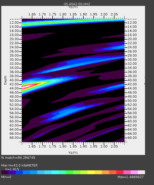
| Estimated Moho Depth: |
43.0 km |
| Estimated Crust Vp/Vs: |
1.62 |
| Assumed Crust Vp: |
6.502 km/s |
| Estimated Crust Vs: |
4.026 km/s |
| Estimated Crust Poisson's Ratio: |
0.19 |
|
| Radial Match: |
98.296745 % |
| Radial Bump: |
266 |
| Transverse Match: |
92.23347 % |
| Transverse Bump: |
400 |
| SOD ConfigId: |
21709731 |
| Insert Time: |
2020-08-05 06:22:27.868 +0000 |
| GWidth: |
2.5 |
| Max Bumps: |
400 |
| Tol: |
0.001 |
|

Signal To Noise
| Channel | StoN | STA | LTA |
| GS:ASA2:00:HHZ:20200722T06:19:54.639008Z | 11.942797 | 1.8795239E-6 | 1.573772E-7 |
| GS:ASA2:00:HH1:20200722T06:19:54.639008Z | 10.095331 | 8.1862885E-7 | 8.108985E-8 |
| GS:ASA2:00:HH2:20200722T06:19:54.639008Z | 10.237373 | 9.0694334E-7 | 8.8591406E-8 |
| Arrivals |
| Ps | 4.4 SECOND |
| PpPs | 16 SECOND |
| PsPs/PpSs | 20 SECOND |


