You are here: Home > Network List > GS - US Geological Survey Networks Stations List
> Station DEC08 Union Local 159 Surface Site > Earthquake Result Viewer
DEC08 Union Local 159 Surface Site - Earthquake Result Viewer
| Earthquake location: |
Alaska Peninsula |
| Earthquake latitude/longitude: |
55.2/-158.6 |
| Earthquake time(UTC): |
2020/07/22 (204) 06:12:44 GMT |
| Earthquake Depth: |
13 km |
| Earthquake Magnitude: |
7.4 Mi |
| Earthquake Catalog/Contributor: |
NEIC PDE/at |
|
| Network: |
GS US Geological Survey Networks |
| Station: |
DEC08 Union Local 159 Surface Site |
| Lat/Lon: |
39.86 N/88.92 W |
| Elevation: |
210 m |
|
| Distance: |
47.4 deg |
| Az: |
78.516 deg |
| Baz: |
313.152 deg |
| Ray Param: |
0.06998603 |
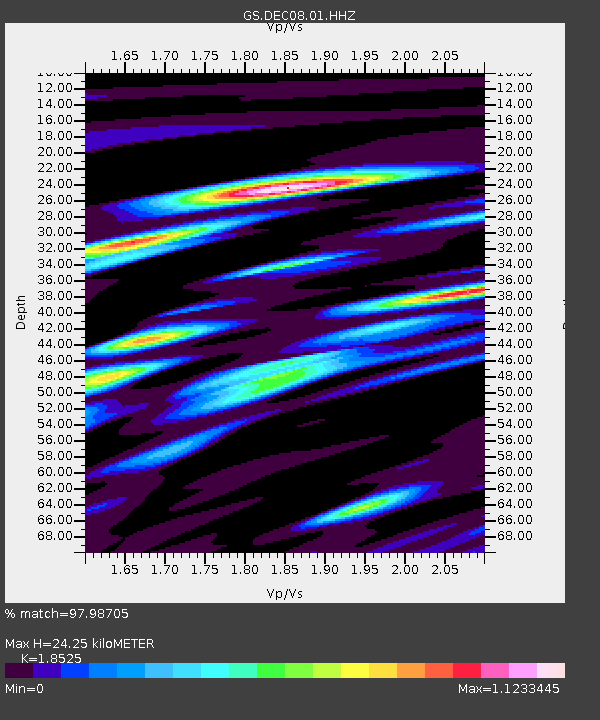
| Estimated Moho Depth: |
24.25 km |
| Estimated Crust Vp/Vs: |
1.85 |
| Assumed Crust Vp: |
6.444 km/s |
| Estimated Crust Vs: |
3.478 km/s |
| Estimated Crust Poisson's Ratio: |
0.29 |
|
| Radial Match: |
97.98705 % |
| Radial Bump: |
386 |
| Transverse Match: |
88.18218 % |
| Transverse Bump: |
400 |
| SOD ConfigId: |
21709731 |
| Insert Time: |
2020-08-05 06:22:39.722 +0000 |
| GWidth: |
2.5 |
| Max Bumps: |
400 |
| Tol: |
0.001 |
|
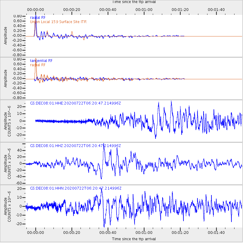
Signal To Noise
| Channel | StoN | STA | LTA |
| GS:DEC08:01:HHZ:20200722T06:20:47.214996Z | 8.302028 | 4.3464047E-6 | 5.2353533E-7 |
| GS:DEC08:01:HHN:20200722T06:20:47.214996Z | 2.1982963 | 2.0465036E-6 | 9.3094974E-7 |
| GS:DEC08:01:HHE:20200722T06:20:47.214996Z | 2.3477693 | 2.2971599E-6 | 9.784436E-7 |
| Arrivals |
| Ps | 3.4 SECOND |
| PpPs | 10 SECOND |
| PsPs/PpSs | 14 SECOND |


