You are here: Home > Network List > GS - US Geological Survey Networks Stations List
> Station DEC09 Kile Street Surface Site > Earthquake Result Viewer
DEC09 Kile Street Surface Site - Earthquake Result Viewer
| Earthquake location: |
Alaska Peninsula |
| Earthquake latitude/longitude: |
55.2/-158.6 |
| Earthquake time(UTC): |
2020/07/22 (204) 06:12:44 GMT |
| Earthquake Depth: |
13 km |
| Earthquake Magnitude: |
7.4 Mi |
| Earthquake Catalog/Contributor: |
NEIC PDE/at |
|
| Network: |
GS US Geological Survey Networks |
| Station: |
DEC09 Kile Street Surface Site |
| Lat/Lon: |
39.87 N/88.92 W |
| Elevation: |
207 m |
|
| Distance: |
47.4 deg |
| Az: |
78.502 deg |
| Baz: |
313.143 deg |
| Ray Param: |
0.06999211 |
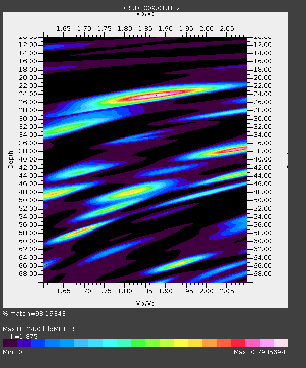
| Estimated Moho Depth: |
24.0 km |
| Estimated Crust Vp/Vs: |
1.88 |
| Assumed Crust Vp: |
6.444 km/s |
| Estimated Crust Vs: |
3.437 km/s |
| Estimated Crust Poisson's Ratio: |
0.30 |
|
| Radial Match: |
98.19343 % |
| Radial Bump: |
304 |
| Transverse Match: |
95.79884 % |
| Transverse Bump: |
400 |
| SOD ConfigId: |
21709731 |
| Insert Time: |
2020-08-05 06:22:40.292 +0000 |
| GWidth: |
2.5 |
| Max Bumps: |
400 |
| Tol: |
0.001 |
|
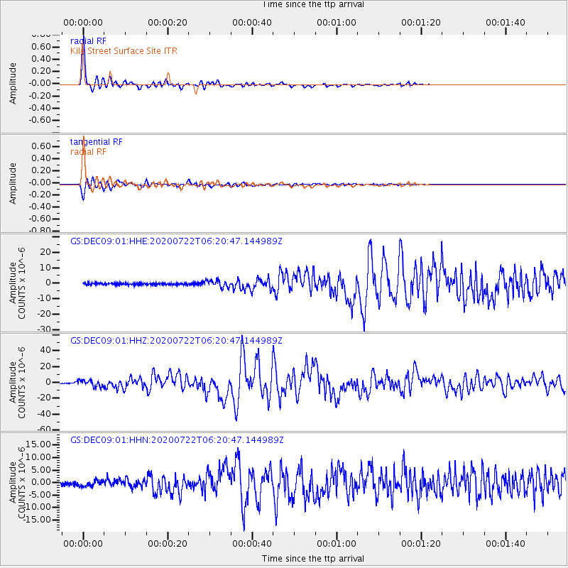
Signal To Noise
| Channel | StoN | STA | LTA |
| GS:DEC09:01:HHZ:20200722T06:20:47.144989Z | 16.777239 | 4.1086687E-6 | 2.4489543E-7 |
| GS:DEC09:01:HHN:20200722T06:20:47.144989Z | 2.1920006 | 1.1435727E-6 | 5.217027E-7 |
| GS:DEC09:01:HHE:20200722T06:20:47.144989Z | 4.0647697 | 2.2983081E-6 | 5.654215E-7 |
| Arrivals |
| Ps | 3.5 SECOND |
| PpPs | 10 SECOND |
| PsPs/PpSs | 14 SECOND |


