You are here: Home > Network List > GS - US Geological Survey Networks Stations List
> Station DEC13 Justin Breden Machine Shed, Decatur, IL, USA > Earthquake Result Viewer
DEC13 Justin Breden Machine Shed, Decatur, IL, USA - Earthquake Result Viewer
| Earthquake location: |
Alaska Peninsula |
| Earthquake latitude/longitude: |
55.2/-158.6 |
| Earthquake time(UTC): |
2020/07/22 (204) 06:12:44 GMT |
| Earthquake Depth: |
13 km |
| Earthquake Magnitude: |
7.4 Mi |
| Earthquake Catalog/Contributor: |
NEIC PDE/at |
|
| Network: |
GS US Geological Survey Networks |
| Station: |
DEC13 Justin Breden Machine Shed, Decatur, IL, USA |
| Lat/Lon: |
39.90 N/88.88 W |
| Elevation: |
224 m |
|
| Distance: |
47.4 deg |
| Az: |
78.443 deg |
| Baz: |
313.132 deg |
| Ray Param: |
0.069987044 |
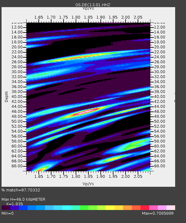
| Estimated Moho Depth: |
46.0 km |
| Estimated Crust Vp/Vs: |
1.84 |
| Assumed Crust Vp: |
6.444 km/s |
| Estimated Crust Vs: |
3.512 km/s |
| Estimated Crust Poisson's Ratio: |
0.29 |
|
| Radial Match: |
97.70332 % |
| Radial Bump: |
353 |
| Transverse Match: |
84.99346 % |
| Transverse Bump: |
400 |
| SOD ConfigId: |
21709731 |
| Insert Time: |
2020-08-05 06:22:43.073 +0000 |
| GWidth: |
2.5 |
| Max Bumps: |
400 |
| Tol: |
0.001 |
|

Signal To Noise
| Channel | StoN | STA | LTA |
| GS:DEC13:01:HHZ:20200722T06:20:47.200012Z | 28.50748 | 4.719707E-6 | 1.6556028E-7 |
| GS:DEC13:01:HHN:20200722T06:20:47.200012Z | 3.4173925 | 2.2796905E-6 | 6.6708475E-7 |
| GS:DEC13:01:HHE:20200722T06:20:47.200012Z | 4.5640492 | 2.6847417E-6 | 5.882368E-7 |
| Arrivals |
| Ps | 6.3 SECOND |
| PpPs | 19 SECOND |
| PsPs/PpSs | 25 SECOND |


