You are here: Home > Network List > GS - US Geological Survey Networks Stations List
> Station OK051 E0350 and S34600 Roads, Ralston, OK > Earthquake Result Viewer
OK051 E0350 and S34600 Roads, Ralston, OK - Earthquake Result Viewer
| Earthquake location: |
Alaska Peninsula |
| Earthquake latitude/longitude: |
55.2/-158.6 |
| Earthquake time(UTC): |
2020/07/22 (204) 06:12:44 GMT |
| Earthquake Depth: |
13 km |
| Earthquake Magnitude: |
7.4 Mi |
| Earthquake Catalog/Contributor: |
NEIC PDE/at |
|
| Network: |
GS US Geological Survey Networks |
| Station: |
OK051 E0350 and S34600 Roads, Ralston, OK |
| Lat/Lon: |
36.51 N/96.84 W |
| Elevation: |
263 m |
|
| Distance: |
45.3 deg |
| Az: |
87.826 deg |
| Baz: |
314.71 deg |
| Ray Param: |
0.07139543 |
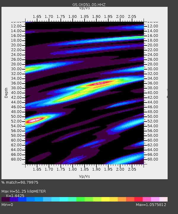
| Estimated Moho Depth: |
51.25 km |
| Estimated Crust Vp/Vs: |
1.64 |
| Assumed Crust Vp: |
6.483 km/s |
| Estimated Crust Vs: |
3.947 km/s |
| Estimated Crust Poisson's Ratio: |
0.21 |
|
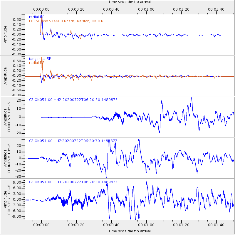
| Radial Match: |
98.79975 % |
| Radial Bump: |
314 |
| Transverse Match: |
96.69711 % |
| Transverse Bump: |
395 |
| SOD ConfigId: |
21709731 |
| Insert Time: |
2020-08-05 06:22:48.869 +0000 |
| GWidth: |
2.5 |
| Max Bumps: |
400 |
| Tol: |
0.001 |
|
Signal To Noise
| Channel | StoN | STA | LTA |
| GS:OK051:00:HHZ:20200722T06:20:30.148987Z | 17.244255 | 2.0223874E-6 | 1.1727891E-7 |
| GS:OK051:00:HH1:20200722T06:20:30.148987Z | 6.9119573 | 5.87801E-7 | 8.504118E-8 |
| GS:OK051:00:HH2:20200722T06:20:30.148987Z | 11.518283 | 1.1228244E-6 | 9.748193E-8 |
| Arrivals |
| Ps | 5.5 SECOND |
| PpPs | 19 SECOND |
| PsPs/PpSs | 25 SECOND |


