You are here: Home > Network List > GS - US Geological Survey Networks Stations List
> Station PR03 PR03, Alturas Sabaneras > Earthquake Result Viewer
PR03 PR03, Alturas Sabaneras - Earthquake Result Viewer
| Earthquake location: |
Alaska Peninsula |
| Earthquake latitude/longitude: |
55.2/-158.6 |
| Earthquake time(UTC): |
2020/07/22 (204) 06:12:44 GMT |
| Earthquake Depth: |
13 km |
| Earthquake Magnitude: |
7.4 Mi |
| Earthquake Catalog/Contributor: |
NEIC PDE/at |
|
| Network: |
GS US Geological Survey Networks |
| Station: |
PR03 PR03, Alturas Sabaneras |
| Lat/Lon: |
18.07 N/66.94 W |
| Elevation: |
113 m |
|
| Distance: |
76.3 deg |
| Az: |
78.171 deg |
| Baz: |
323.875 deg |
| Ray Param: |
0.051089697 |
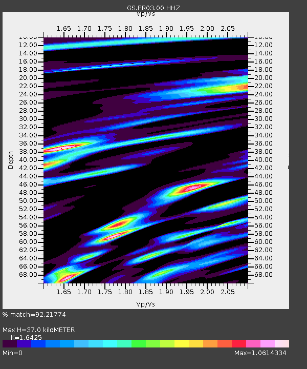
| Estimated Moho Depth: |
37.0 km |
| Estimated Crust Vp/Vs: |
1.64 |
| Assumed Crust Vp: |
5.14 km/s |
| Estimated Crust Vs: |
3.129 km/s |
| Estimated Crust Poisson's Ratio: |
0.21 |
|
| Radial Match: |
92.21774 % |
| Radial Bump: |
400 |
| Transverse Match: |
90.4581 % |
| Transverse Bump: |
400 |
| SOD ConfigId: |
21709731 |
| Insert Time: |
2020-08-05 06:22:54.693 +0000 |
| GWidth: |
2.5 |
| Max Bumps: |
400 |
| Tol: |
0.001 |
|

Signal To Noise
| Channel | StoN | STA | LTA |
| GS:PR03:00:HHZ:20200722T06:24:01.06897Z | 13.574481 | 3.7793043E-6 | 2.7841241E-7 |
| GS:PR03:00:HH1:20200722T06:24:01.06897Z | 6.816589 | 1.3566067E-6 | 1.990155E-7 |
| GS:PR03:00:HH2:20200722T06:24:01.06897Z | 3.0360548 | 8.680785E-7 | 2.859232E-7 |
| Arrivals |
| Ps | 4.7 SECOND |
| PpPs | 19 SECOND |
| PsPs/PpSs | 23 SECOND |


