You are here: Home > Network List > GS - US Geological Survey Networks Stations List
> Station PR04 PR04, Ponce > Earthquake Result Viewer
PR04 PR04, Ponce - Earthquake Result Viewer
| Earthquake location: |
Alaska Peninsula |
| Earthquake latitude/longitude: |
55.2/-158.6 |
| Earthquake time(UTC): |
2020/07/22 (204) 06:12:44 GMT |
| Earthquake Depth: |
13 km |
| Earthquake Magnitude: |
7.4 Mi |
| Earthquake Catalog/Contributor: |
NEIC PDE/at |
|
| Network: |
GS US Geological Survey Networks |
| Station: |
PR04 PR04, Ponce |
| Lat/Lon: |
17.98 N/66.67 W |
| Elevation: |
57 m |
|
| Distance: |
76.5 deg |
| Az: |
78.013 deg |
| Baz: |
323.92 deg |
| Ray Param: |
0.050942235 |
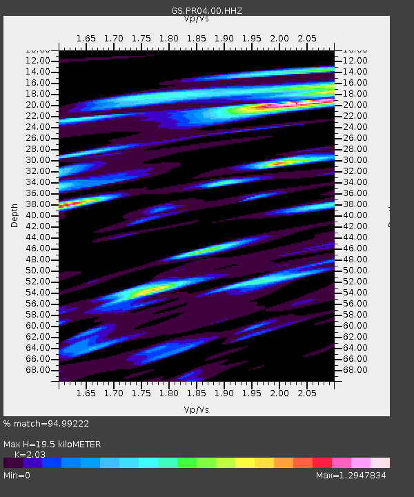
| Estimated Moho Depth: |
19.5 km |
| Estimated Crust Vp/Vs: |
2.03 |
| Assumed Crust Vp: |
4.082 km/s |
| Estimated Crust Vs: |
2.011 km/s |
| Estimated Crust Poisson's Ratio: |
0.34 |
|
| Radial Match: |
94.99222 % |
| Radial Bump: |
400 |
| Transverse Match: |
94.662445 % |
| Transverse Bump: |
400 |
| SOD ConfigId: |
21709731 |
| Insert Time: |
2020-08-05 06:22:55.870 +0000 |
| GWidth: |
2.5 |
| Max Bumps: |
400 |
| Tol: |
0.001 |
|

Signal To Noise
| Channel | StoN | STA | LTA |
| GS:PR04:00:HHZ:20200722T06:24:02.31897Z | 31.856245 | 5.7837256E-6 | 1.8155704E-7 |
| GS:PR04:00:HH1:20200722T06:24:02.31897Z | 5.318051 | 1.6040259E-6 | 3.0161914E-7 |
| GS:PR04:00:HH2:20200722T06:24:02.31897Z | 3.616581 | 1.144707E-6 | 3.1651632E-7 |
| Arrivals |
| Ps | 5.0 SECOND |
| PpPs | 14 SECOND |
| PsPs/PpSs | 19 SECOND |


