You are here: Home > Network List > GS - US Geological Survey Networks Stations List
> Station PR06 PR06, Penuelas > Earthquake Result Viewer
PR06 PR06, Penuelas - Earthquake Result Viewer
| Earthquake location: |
Alaska Peninsula |
| Earthquake latitude/longitude: |
55.2/-158.6 |
| Earthquake time(UTC): |
2020/07/22 (204) 06:12:44 GMT |
| Earthquake Depth: |
13 km |
| Earthquake Magnitude: |
7.4 Mi |
| Earthquake Catalog/Contributor: |
NEIC PDE/at |
|
| Network: |
GS US Geological Survey Networks |
| Station: |
PR06 PR06, Penuelas |
| Lat/Lon: |
18.06 N/66.72 W |
| Elevation: |
56 m |
|
| Distance: |
76.4 deg |
| Az: |
78.009 deg |
| Baz: |
323.902 deg |
| Ray Param: |
0.051004697 |
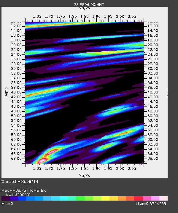
| Estimated Moho Depth: |
68.75 km |
| Estimated Crust Vp/Vs: |
1.67 |
| Assumed Crust Vp: |
5.14 km/s |
| Estimated Crust Vs: |
3.078 km/s |
| Estimated Crust Poisson's Ratio: |
0.22 |
|
| Radial Match: |
95.06414 % |
| Radial Bump: |
400 |
| Transverse Match: |
91.96399 % |
| Transverse Bump: |
400 |
| SOD ConfigId: |
21709731 |
| Insert Time: |
2020-08-05 06:22:58.819 +0000 |
| GWidth: |
2.5 |
| Max Bumps: |
400 |
| Tol: |
0.001 |
|

Signal To Noise
| Channel | StoN | STA | LTA |
| GS:PR06:00:HHZ:20200722T06:24:01.797974Z | 29.105124 | 4.175221E-6 | 1.4345312E-7 |
| GS:PR06:00:HH1:20200722T06:24:01.797974Z | 8.057995 | 1.4529239E-6 | 1.8030838E-7 |
| GS:PR06:00:HH2:20200722T06:24:01.797974Z | 5.949712 | 8.8672465E-7 | 1.4903658E-7 |
| Arrivals |
| Ps | 9.2 SECOND |
| PpPs | 35 SECOND |
| PsPs/PpSs | 44 SECOND |


