You are here: Home > Network List > HV - Hawaiian Volcano Observatory Network Stations List
> Station HAT Halemaumau Trail > Earthquake Result Viewer
HAT Halemaumau Trail - Earthquake Result Viewer
| Earthquake location: |
Alaska Peninsula |
| Earthquake latitude/longitude: |
55.2/-158.6 |
| Earthquake time(UTC): |
2020/07/22 (204) 06:12:44 GMT |
| Earthquake Depth: |
13 km |
| Earthquake Magnitude: |
7.4 Mi |
| Earthquake Catalog/Contributor: |
NEIC PDE/at |
|
| Network: |
HV Hawaiian Volcano Observatory Network |
| Station: |
HAT Halemaumau Trail |
| Lat/Lon: |
19.42 N/155.26 W |
| Elevation: |
1097 m |
|
| Distance: |
35.8 deg |
| Az: |
174.621 deg |
| Baz: |
356.737 deg |
| Ray Param: |
0.07701759 |
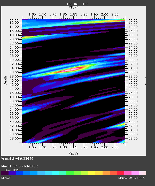
| Estimated Moho Depth: |
34.5 km |
| Estimated Crust Vp/Vs: |
1.84 |
| Assumed Crust Vp: |
5.195 km/s |
| Estimated Crust Vs: |
2.831 km/s |
| Estimated Crust Poisson's Ratio: |
0.29 |
|
| Radial Match: |
86.33649 % |
| Radial Bump: |
400 |
| Transverse Match: |
84.65888 % |
| Transverse Bump: |
400 |
| SOD ConfigId: |
21709731 |
| Insert Time: |
2020-08-05 06:23:23.989 +0000 |
| GWidth: |
2.5 |
| Max Bumps: |
400 |
| Tol: |
0.001 |
|

Signal To Noise
| Channel | StoN | STA | LTA |
| HV:HAT: :HHZ:20200722T06:19:12.324005Z | 9.901066 | 7.857467E-6 | 7.935981E-7 |
| HV:HAT: :HHN:20200722T06:19:12.324005Z | 4.1313734 | 7.431468E-6 | 1.7987888E-6 |
| HV:HAT: :HHE:20200722T06:19:12.324005Z | 1.3144644 | 2.1701983E-6 | 1.6510133E-6 |
| Arrivals |
| Ps | 5.8 SECOND |
| PpPs | 18 SECOND |
| PsPs/PpSs | 24 SECOND |


