You are here: Home > Network List > HV - Hawaiian Volcano Observatory Network Stations List
> Station HLPD Hilina Pali, Hawaii Digital > Earthquake Result Viewer
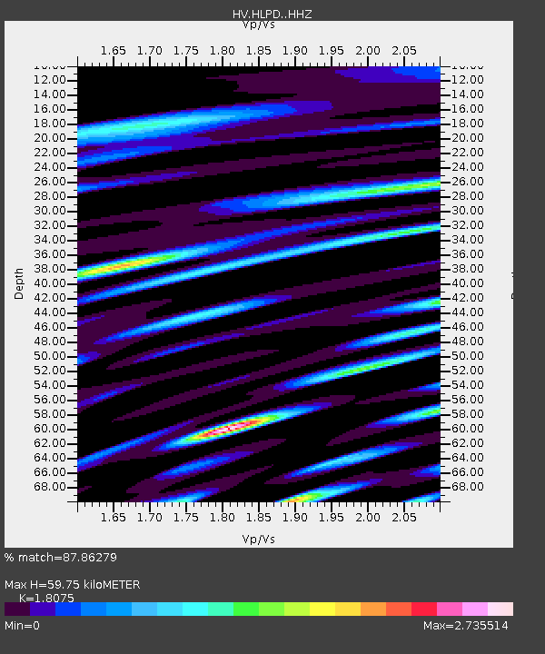
HLPD Hilina Pali, Hawaii Digital - Earthquake Result Viewer
| Earthquake location: |
Alaska Peninsula |
| Earthquake latitude/longitude: |
55.2/-158.6 |
| Earthquake time(UTC): |
2020/07/22 (204) 06:12:44 GMT |
| Earthquake Depth: |
13 km |
| Earthquake Magnitude: |
7.4 Mi |
| Earthquake Catalog/Contributor: |
NEIC PDE/at |
|
| Network: |
HV Hawaiian Volcano Observatory Network |
| Station: |
HLPD Hilina Pali, Hawaii Digital |
| Lat/Lon: |
19.30 N/155.31 W |
| Elevation: |
706 m |
|
| Distance: |
35.9 deg |
| Az: |
174.708 deg |
| Baz: |
356.792 deg |
| Ray Param: |
0.07695931 |
| Estimated Moho Depth: |
59.75 km |
| Estimated Crust Vp/Vs: |
1.81 |
| Assumed Crust Vp: |
5.195 km/s |
| Estimated Crust Vs: |
2.874 km/s |
| Estimated Crust Poisson's Ratio: |
0.28 |
|
| Radial Match: |
87.86279 % |
| Radial Bump: |
400 |
| Transverse Match: |
80.33794 % |
| Transverse Bump: |
400 |
| SOD ConfigId: |
21709731 |
| Insert Time: |
2020-08-05 06:23:25.099 +0000 |
| GWidth: |
2.5 |
| Max Bumps: |
400 |
| Tol: |
0.001 |
|

Signal To Noise
| Channel | StoN | STA | LTA |
| HV:HLPD: :HHZ:20200722T06:19:13.373993Z | 5.5084233 | 1.0301078E-5 | 1.8700592E-6 |
| HV:HLPD: :HHN:20200722T06:19:13.373993Z | 4.7292747 | 9.214593E-6 | 1.9484157E-6 |
| HV:HLPD: :HHE:20200722T06:19:13.373993Z | 1.0452055 | 3.5860094E-6 | 3.4309132E-6 |
| Arrivals |
| Ps | 9.7 SECOND |
| PpPs | 31 SECOND |
| PsPs/PpSs | 41 SECOND |


