You are here: Home > Network List > HV - Hawaiian Volcano Observatory Network Stations List
> Station OBL Observatory Bluff > Earthquake Result Viewer
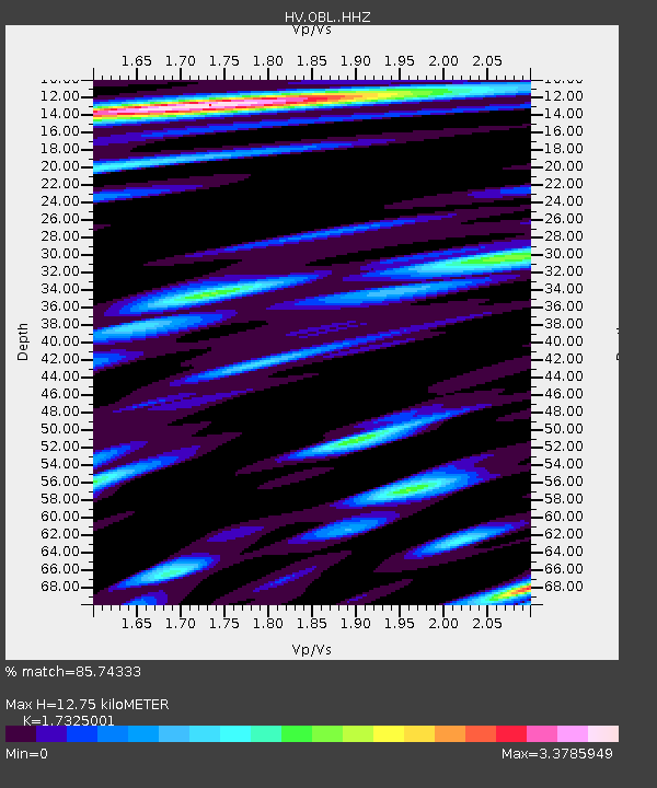
OBL Observatory Bluff - Earthquake Result Viewer
| Earthquake location: |
Alaska Peninsula |
| Earthquake latitude/longitude: |
55.2/-158.6 |
| Earthquake time(UTC): |
2020/07/22 (204) 06:12:44 GMT |
| Earthquake Depth: |
13 km |
| Earthquake Magnitude: |
7.4 Mi |
| Earthquake Catalog/Contributor: |
NEIC PDE/at |
|
| Network: |
HV Hawaiian Volcano Observatory Network |
| Station: |
OBL Observatory Bluff |
| Lat/Lon: |
19.42 N/155.28 W |
| Elevation: |
1119 m |
|
| Distance: |
35.8 deg |
| Az: |
174.659 deg |
| Baz: |
356.76 deg |
| Ray Param: |
0.07701578 |
| Estimated Moho Depth: |
12.75 km |
| Estimated Crust Vp/Vs: |
1.73 |
| Assumed Crust Vp: |
5.195 km/s |
| Estimated Crust Vs: |
2.999 km/s |
| Estimated Crust Poisson's Ratio: |
0.25 |
|
| Radial Match: |
85.74333 % |
| Radial Bump: |
400 |
| Transverse Match: |
78.94338 % |
| Transverse Bump: |
400 |
| SOD ConfigId: |
21709731 |
| Insert Time: |
2020-08-05 06:23:37.211 +0000 |
| GWidth: |
2.5 |
| Max Bumps: |
400 |
| Tol: |
0.001 |
|

Signal To Noise
| Channel | StoN | STA | LTA |
| HV:OBL: :HHZ:20200722T06:19:12.354004Z | 7.721217 | 8.275093E-6 | 1.0717342E-6 |
| HV:OBL: :HHN:20200722T06:19:12.354004Z | 3.2667358 | 6.9126104E-6 | 2.1160604E-6 |
| HV:OBL: :HHE:20200722T06:19:12.354004Z | 1.2575129 | 3.663543E-6 | 2.9133246E-6 |
| Arrivals |
| Ps | 1.9 SECOND |
| PpPs | 6.4 SECOND |
| PsPs/PpSs | 8.3 SECOND |


