You are here: Home > Network List > IM - International Miscellaneous Stations Stations List
> Station PD31 PDAR Array, Pinedale, WY, USA > Earthquake Result Viewer
PD31 PDAR Array, Pinedale, WY, USA - Earthquake Result Viewer
| Earthquake location: |
Alaska Peninsula |
| Earthquake latitude/longitude: |
55.2/-158.6 |
| Earthquake time(UTC): |
2020/07/22 (204) 06:12:44 GMT |
| Earthquake Depth: |
13 km |
| Earthquake Magnitude: |
7.4 Mi |
| Earthquake Catalog/Contributor: |
NEIC PDE/at |
|
| Network: |
IM International Miscellaneous Stations |
| Station: |
PD31 PDAR Array, Pinedale, WY, USA |
| Lat/Lon: |
42.77 N/109.56 W |
| Elevation: |
2219 m |
|
| Distance: |
33.8 deg |
| Az: |
90.821 deg |
| Baz: |
308.917 deg |
| Ray Param: |
0.0780559 |
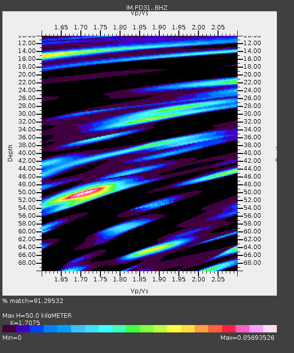
| Estimated Moho Depth: |
50.0 km |
| Estimated Crust Vp/Vs: |
1.71 |
| Assumed Crust Vp: |
6.161 km/s |
| Estimated Crust Vs: |
3.608 km/s |
| Estimated Crust Poisson's Ratio: |
0.24 |
|
| Radial Match: |
91.29532 % |
| Radial Bump: |
400 |
| Transverse Match: |
87.00936 % |
| Transverse Bump: |
400 |
| SOD ConfigId: |
21709731 |
| Insert Time: |
2020-08-05 06:24:22.971 +0000 |
| GWidth: |
2.5 |
| Max Bumps: |
400 |
| Tol: |
0.001 |
|

Signal To Noise
| Channel | StoN | STA | LTA |
| IM:PD31: :BHZ:20200722T06:18:54.774994Z | 32.622005 | 2.549739E-6 | 7.816009E-8 |
| IM:PD31: :BHN:20200722T06:18:54.774994Z | 14.083265 | 6.9238325E-7 | 4.9163546E-8 |
| IM:PD31: :BHE:20200722T06:18:54.774994Z | 11.464021 | 8.536544E-7 | 7.4463784E-8 |
| Arrivals |
| Ps | 6.2 SECOND |
| PpPs | 20 SECOND |
| PsPs/PpSs | 27 SECOND |


