You are here: Home > Network List > JP - Japan Meteorological Agency Seismic Network Stations List
> Station JKA Kamikawa Asahi > Earthquake Result Viewer
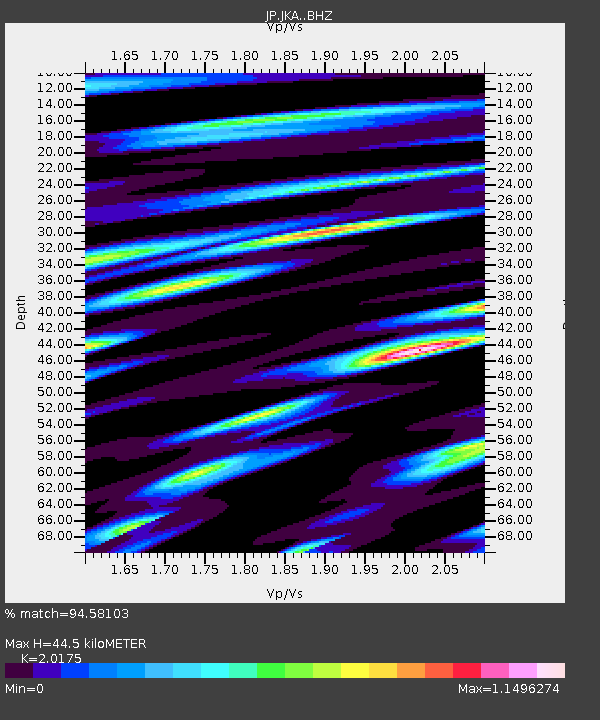
JKA Kamikawa Asahi - Earthquake Result Viewer
| Earthquake location: |
Alaska Peninsula |
| Earthquake latitude/longitude: |
55.2/-158.6 |
| Earthquake time(UTC): |
2020/07/22 (204) 06:12:44 GMT |
| Earthquake Depth: |
13 km |
| Earthquake Magnitude: |
7.4 Mi |
| Earthquake Catalog/Contributor: |
NEIC PDE/at |
|
| Network: |
JP Japan Meteorological Agency Seismic Network |
| Station: |
JKA Kamikawa Asahi |
| Lat/Lon: |
41.12 N/142.59 E |
| Elevation: |
220 m |
|
| Distance: |
40.4 deg |
| Az: |
274.842 deg |
| Baz: |
49.088 deg |
| Ray Param: |
0.07439412 |
| Estimated Moho Depth: |
44.5 km |
| Estimated Crust Vp/Vs: |
2.02 |
| Assumed Crust Vp: |
6.183 km/s |
| Estimated Crust Vs: |
3.064 km/s |
| Estimated Crust Poisson's Ratio: |
0.34 |
|
| Radial Match: |
94.58103 % |
| Radial Bump: |
400 |
| Transverse Match: |
89.069466 % |
| Transverse Bump: |
400 |
| SOD ConfigId: |
21709731 |
| Insert Time: |
2020-08-05 06:25:19.139 +0000 |
| GWidth: |
2.5 |
| Max Bumps: |
400 |
| Tol: |
0.001 |
|

Signal To Noise
| Channel | StoN | STA | LTA |
| JP:JKA: :BHZ:20200722T06:19:35.250Z | 2.4651682 | 3.594208E-5 | 1.457997E-5 |
| JP:JKA: :BHN:20200722T06:19:35.250Z | 3.7992475 | 1.5627753E-5 | 4.1133812E-6 |
| JP:JKA: :BHE:20200722T06:19:35.250Z | 3.6657634 | 2.753994E-5 | 7.5127437E-6 |
| Arrivals |
| Ps | 7.7 SECOND |
| PpPs | 21 SECOND |
| PsPs/PpSs | 28 SECOND |


