You are here: Home > Network List > GS - US Geological Survey Networks Stations List
> Station DEC08 Decatur Surface Seismic Site, Decatur, IL, USA > Earthquake Result Viewer
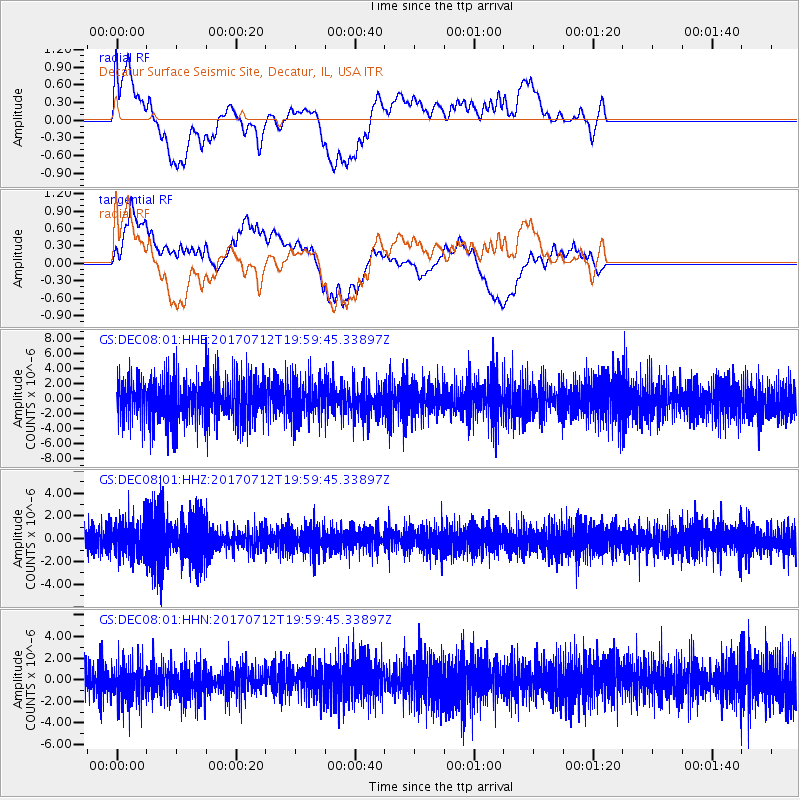
DEC08 Decatur Surface Seismic Site, Decatur, IL, USA - Earthquake Result Viewer
*The percent match for this event was below the threshold and hence no stack was calculated.
| Earthquake location: |
Sea Of Japan |
| Earthquake latitude/longitude: |
40.9/131.6 |
| Earthquake time(UTC): |
2017/07/12 (193) 19:48:07 GMT |
| Earthquake Depth: |
538 km |
| Earthquake Magnitude: |
5.8 Mww |
| Earthquake Catalog/Contributor: |
NEIC PDE/us |
|
| Network: |
GS US Geological Survey Networks |
| Station: |
DEC08 Decatur Surface Seismic Site, Decatur, IL, USA |
| Lat/Lon: |
39.86 N/88.92 W |
| Elevation: |
210 m |
|
| Distance: |
91.6 deg |
| Az: |
30.045 deg |
| Baz: |
330.436 deg |
| Ray Param: |
$rayparam |
*The percent match for this event was below the threshold and hence was not used in the summary stack. |
|
| Radial Match: |
41.699047 % |
| Radial Bump: |
400 |
| Transverse Match: |
67.33628 % |
| Transverse Bump: |
400 |
| SOD ConfigId: |
2140511 |
| Insert Time: |
2017-07-26 11:43:22.172 +0000 |
| GWidth: |
2.5 |
| Max Bumps: |
400 |
| Tol: |
0.001 |
|
Signal To Noise
| Channel | StoN | STA | LTA |
| GS:DEC08:01:HHZ:20170712T19:59:45.33897Z | 1.6704265 | 1.3859886E-6 | 8.2972144E-7 |
| GS:DEC08:01:HHN:20170712T19:59:45.33897Z | 0.97085845 | 1.7756499E-6 | 1.8289484E-6 |
| GS:DEC08:01:HHE:20170712T19:59:45.33897Z | 0.8561885 | 2.430417E-6 | 2.838647E-6 |
| Arrivals |
| Ps | |
| PpPs | |
| PsPs/PpSs | |


