You are here: Home > Network List > KR - Kyrgyz Digital Network Stations List
> Station PRZ Karakol, Kyrgyzstan > Earthquake Result Viewer
PRZ Karakol, Kyrgyzstan - Earthquake Result Viewer
| Earthquake location: |
Alaska Peninsula |
| Earthquake latitude/longitude: |
55.2/-158.6 |
| Earthquake time(UTC): |
2020/07/22 (204) 06:12:44 GMT |
| Earthquake Depth: |
13 km |
| Earthquake Magnitude: |
7.4 Mi |
| Earthquake Catalog/Contributor: |
NEIC PDE/at |
|
| Network: |
KR Kyrgyz Digital Network |
| Station: |
PRZ Karakol, Kyrgyzstan |
| Lat/Lon: |
42.47 N/78.40 E |
| Elevation: |
1835 m |
|
| Distance: |
71.3 deg |
| Az: |
319.082 deg |
| Baz: |
30.483 deg |
| Ray Param: |
0.054411378 |
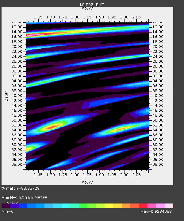
| Estimated Moho Depth: |
15.25 km |
| Estimated Crust Vp/Vs: |
1.60 |
| Assumed Crust Vp: |
6.306 km/s |
| Estimated Crust Vs: |
3.941 km/s |
| Estimated Crust Poisson's Ratio: |
0.18 |
|
| Radial Match: |
88.35729 % |
| Radial Bump: |
400 |
| Transverse Match: |
79.955315 % |
| Transverse Bump: |
400 |
| SOD ConfigId: |
21709731 |
| Insert Time: |
2020-08-05 06:26:06.739 +0000 |
| GWidth: |
2.5 |
| Max Bumps: |
400 |
| Tol: |
0.001 |
|

Signal To Noise
| Channel | StoN | STA | LTA |
| KR:PRZ: :BHZ:20200722T06:23:31.780029Z | 54.16412 | 1.5797945E-5 | 2.9166804E-7 |
| KR:PRZ: :BHN:20200722T06:23:31.780029Z | 29.272083 | 5.703888E-6 | 1.948576E-7 |
| KR:PRZ: :BHE:20200722T06:23:31.780029Z | 5.541608 | 1.5799059E-6 | 2.8509882E-7 |
| Arrivals |
| Ps | 1.5 SECOND |
| PpPs | 6.1 SECOND |
| PsPs/PpSs | 7.6 SECOND |


