You are here: Home > Network List > MM - Myanmar National Seismic Network Stations List
> Station YGN Yangon, Yangon, Myanmar > Earthquake Result Viewer
YGN Yangon, Yangon, Myanmar - Earthquake Result Viewer
| Earthquake location: |
Alaska Peninsula |
| Earthquake latitude/longitude: |
55.2/-158.6 |
| Earthquake time(UTC): |
2020/07/22 (204) 06:12:44 GMT |
| Earthquake Depth: |
13 km |
| Earthquake Magnitude: |
7.4 Mi |
| Earthquake Catalog/Contributor: |
NEIC PDE/at |
|
| Network: |
MM Myanmar National Seismic Network |
| Station: |
YGN Yangon, Yangon, Myanmar |
| Lat/Lon: |
16.86 N/96.15 E |
| Elevation: |
20 m |
|
| Distance: |
84.7 deg |
| Az: |
291.916 deg |
| Baz: |
33.723 deg |
| Ray Param: |
0.04527824 |
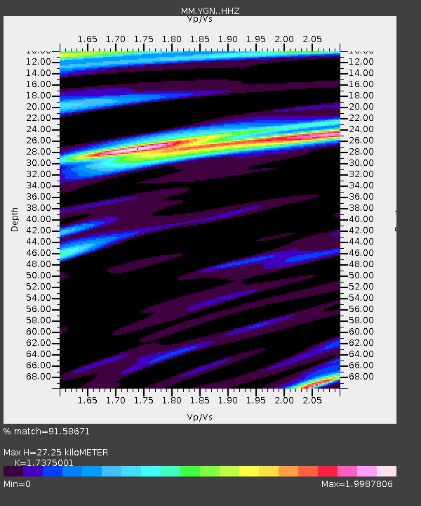
| Estimated Moho Depth: |
27.25 km |
| Estimated Crust Vp/Vs: |
1.74 |
| Assumed Crust Vp: |
6.287 km/s |
| Estimated Crust Vs: |
3.619 km/s |
| Estimated Crust Poisson's Ratio: |
0.25 |
|
| Radial Match: |
91.58671 % |
| Radial Bump: |
400 |
| Transverse Match: |
87.75558 % |
| Transverse Bump: |
400 |
| SOD ConfigId: |
21709731 |
| Insert Time: |
2020-08-05 06:27:30.779 +0000 |
| GWidth: |
2.5 |
| Max Bumps: |
400 |
| Tol: |
0.001 |
|

Signal To Noise
| Channel | StoN | STA | LTA |
| MM:YGN: :HHZ:20200722T06:24:46.107971Z | 4.7167115 | 1.3746127E-5 | 2.9143453E-6 |
| MM:YGN: :HHN:20200722T06:24:46.107971Z | 1.6342764 | 5.175975E-6 | 3.1671354E-6 |
| MM:YGN: :HHE:20200722T06:24:46.107971Z | 1.0928085 | 3.5270575E-6 | 3.2275166E-6 |
| Arrivals |
| Ps | 3.3 SECOND |
| PpPs | 12 SECOND |
| PsPs/PpSs | 15 SECOND |


