You are here: Home > Network List > N4 - Central and EAstern US Network Stations List
> Station 451A Vernon, FL, USA > Earthquake Result Viewer
451A Vernon, FL, USA - Earthquake Result Viewer
| Earthquake location: |
Alaska Peninsula |
| Earthquake latitude/longitude: |
55.2/-158.6 |
| Earthquake time(UTC): |
2020/07/22 (204) 06:12:44 GMT |
| Earthquake Depth: |
13 km |
| Earthquake Magnitude: |
7.4 Mi |
| Earthquake Catalog/Contributor: |
NEIC PDE/at |
|
| Network: |
N4 Central and EAstern US Network |
| Station: |
451A Vernon, FL, USA |
| Lat/Lon: |
30.62 N/85.75 W |
| Elevation: |
20 m |
|
| Distance: |
55.9 deg |
| Az: |
84.315 deg |
| Baz: |
318.593 deg |
| Ray Param: |
0.06451296 |
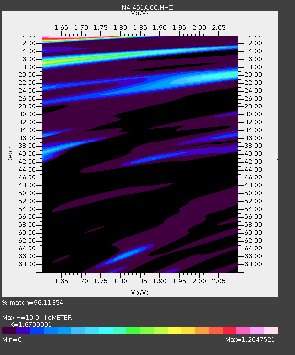
| Estimated Moho Depth: |
10.0 km |
| Estimated Crust Vp/Vs: |
1.67 |
| Assumed Crust Vp: |
6.347 km/s |
| Estimated Crust Vs: |
3.801 km/s |
| Estimated Crust Poisson's Ratio: |
0.22 |
|
| Radial Match: |
96.11354 % |
| Radial Bump: |
358 |
| Transverse Match: |
91.37197 % |
| Transverse Bump: |
400 |
| SOD ConfigId: |
21709731 |
| Insert Time: |
2020-08-05 06:28:07.158 +0000 |
| GWidth: |
2.5 |
| Max Bumps: |
400 |
| Tol: |
0.001 |
|

Signal To Noise
| Channel | StoN | STA | LTA |
| N4:451A:00:HHZ:20200722T06:21:50.189026Z | 6.667377 | 3.1450327E-6 | 4.7170462E-7 |
| N4:451A:00:HH1:20200722T06:21:50.189026Z | 3.5770488 | 1.4838441E-6 | 4.1482357E-7 |
| N4:451A:00:HH2:20200722T06:21:50.189026Z | 3.0180485 | 1.0659646E-6 | 3.5319664E-7 |
| Arrivals |
| Ps | 1.1 SECOND |
| PpPs | 4.0 SECOND |
| PsPs/PpSs | 5.1 SECOND |


